 Filter: Categories of Wisconsin Historical Images
Filter: Subject of Maps
Filter: Year of 1900-1999
Filter: Year of 1960-1969
Filter: Categories of Wisconsin Historical Images
Filter: Subject of Maps
Filter: Year of 1900-1999
Filter: Year of 1960-1969

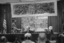
| Date: | 01 25 1964 |
|---|---|
| Description: | Oscar G. Mayer Jr., president of the Oscar Mayer Company, at a podium on the stage of the Orpheum Theatre. On the screen is a large map of United States wi... |

| Date: | 04 21 1964 |
|---|---|
| Description: | Two women employees of the Madison Chamber of Commerce office inspecting a newly published map of Madison. They are Beverly Robinson (left) administrative ... |

| Date: | 04 14 1964 |
|---|---|
| Description: | An informal portrait of Morris Rubin sitting at his desk, decked with a glass ashtray, pack of cigarette and matchbook, rotary-dial telephone and papers. S... |
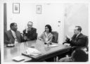
| Date: | 10 1962 |
|---|---|
| Description: | Newton Minow (far right) is seated at a table with members of his staff at the Communications Research Center. There is a large map on the wall on the righ... |
| Date: | 1962 |
|---|---|
| Description: | Newton Minow (fourth from the right) poses with members of his staff in front of a large map on a wall. |

| Date: | 1961 |
|---|---|
| Description: | Newton Minow and another man have a discussion in front of a map. |

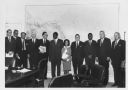
| Date: | 1962 |
|---|---|
| Description: | John F. White, president of National Educational Television and Radio Center (left), and Newton Minow, F.C.C. chairman (center) join Eleanor Roosevelt in a... |

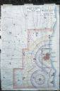
| Date: | 01 08 1965 |
|---|---|
| Description: | The new master plan for the Henry Vilas park and zoo is reviewed by Atty. George F. Lange, president of the Henry Vilas Zoological Society, Inc. and Mrs. G... |

| Date: | 04 13 1965 |
|---|---|
| Description: | Al Schurch, Mr. Horeb, captain of the Zor Shrine Camel patrol, presents a donation to Paul Hartung, president of the Madison Junior Chamber of Commerce for... |

| Date: | 08 13 1965 |
|---|---|
| Description: | H.O. Lord, Madison Metropolitan Sewerage District chief engineer, outlining the existing sewerage district on a map. Lord is trying to educate the public c... |

| Date: | 09 24 1965 |
|---|---|
| Description: | Portrait of Dane County Planning Director Charles Montemayor at a table showing a map of his recently approved re-apportionment plan which would cut the nu... |

| Date: | 10 15 1965 |
|---|---|
| Description: | Town of Madison chairman Harvey Schmidt is pointing out the boundary lines of the township around the city of Madison. |

| Date: | 1966 |
|---|---|
| Description: | This blue line print shows existing and proposed streets, docks, company-owned land, railroads and railroad yards, parks, and municipal airport. |

| Date: | 11 1964 |
|---|---|
| Description: | Fold-out map of the zoo inside a publication titled: "Henry Vilas Park Zoo: An Instructive Book on the Origin and Habits of Animals." Includes Lake Wingra,... |
| Date: | 06 1960 |
|---|---|
| Description: | Photograph of street map of the Village of Shorewood Hills and Blackhawk Country Club. Lake Mendota is at the top of the map. |

| Date: | 09 27 1960 |
|---|---|
| Description: | Members of the Madison Chamber of Commerce staff and board show off a new brochure promoting the city. The brochure includes sections on the State Capitol,... |

| Date: | 11 09 1960 |
|---|---|
| Description: | Chet Bible, owner of Madison Mobile Homes along the Madison Beltline, points to his property on a map at a hearing held in the City-County building by the ... |
| Date: | 11 09 1960 |
|---|---|
| Description: | A display to illustrate proposed improvements to the Madison Beltline highway at a hearing in the City-County Building by the State Highway Commission. |
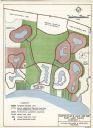
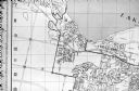
| Date: | 03 28 1964 |
|---|---|
| Description: | A master plan and land use map for East Lake Wales in Polk County, Florida showing where industrial sites, a shopping and civic center, golf course, marina... |
| Date: | 1960 |
|---|---|
| Description: | Map showing the probable blast radius of a 20 megaton bomb on Milwaukee. The map also shows existing hospitals in the area, including outside Milwaukee Cou... |
If you didn't find the material you searched for, our Library Reference Staff can help.
Call our reference desk at 608-264-6535 or email us at: