 Filter: Categories of Wisconsin Historical Images
Filter: Subject of Maps
Filter: Year of 1800-1899
Filter: Year of 1800-1809
Filter: Categories of Wisconsin Historical Images
Filter: Subject of Maps
Filter: Year of 1800-1899
Filter: Year of 1800-1809
| Date: | 1809 |
|---|---|
| Description: | Embroidered sampler of a map of the United States. |
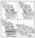
| Date: | 01 11 1805 |
|---|---|
| Description: | Four map illustrations showing the political subdivisions of the Northwest Territory from 1805 through 1834. |

| Date: | 1806 |
|---|---|
| Description: | Prehistoric Indian fortification on Hurricane Creek. |

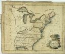
| Date: | 1805 |
|---|---|
| Description: | Map of the United States. It shows the states, cities, towns, Native American land, mountains, lakes, and rivers. Tennessee, Kentucky, and Ohio are labeled... |

| Date: | 1800 |
|---|---|
| Description: | Map of the United States. It shows the states, including Tennessee, cities, towns, Native American land, mountains, lakes, and rivers. Lead mines appear ju... |
If you didn't find the material you searched for, our Library Reference Staff can help.
Call our reference desk at 608-264-6535 or email us at: