Filter: Categories of Wisconsin Historical Images
Filter: Subject of Maps
Filter: Year of 1800-1899
Filter: Categories of Wisconsin Historical Images
Filter: Subject of Maps
Filter: Year of 1800-1899
| Date: | 1899 |
|---|---|
| Description: | Back cover of an advertising catalog for D.M. Osborne and Company showing a schoolmaster in front of men from many nations. Includes the caption "all natio... |

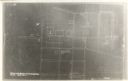
| Date: | 12 26 1862 |
|---|---|
| Description: | Handsketched map of the area around Knobs Gap. |

| Date: | 1829 |
|---|---|
| Description: | Map of lead mines operating in Wisconsin. |

| Date: | 1855 |
|---|---|
| Description: | Fox-Wisconsin portage and canal map, when the canal was not yet built. From a map in the office of the city clerk at Portage. "The old trail, the location ... |
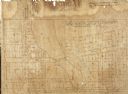
| Date: | 1857 |
|---|---|
| Description: | Plat map of Kekoskee, Wisconsin. Kekoskee is a village in Dodge County, in the Beaver Dam metropolitan area. The community name derives from Indian term fo... |

| Date: | 1862 |
|---|---|
| Description: | Birds-eye view of a Wisconsin Civil War regiment on parade in Fond du Lac, as drawn by Louis Kurz from the Marr Street Methodist Church. The regiment canno... |

| Date: | 1837 |
|---|---|
| Description: | Copy of N.F. Hyer's original map of Aztalan as published in the Milwaukee Advertiser, February 25, 1837. |
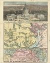
| Date: | 08 1861 |
|---|---|
| Description: | Large-format, illustrated stationery purchased by Rudolph Fine, a member of the 6th Wisconsin Infantry in August, 1861, showing the Capitol (in actuality, ... |
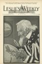
| Date: | 06 09 1898 |
|---|---|
| Description: | Cover art for Leslie's Weekly depicting Uncle Sam peering through a magnifying glass at the Philippine Islands on a globe. The caption reads: "Guess... |
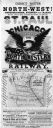
| Date: | 1853 |
|---|---|
| Description: | Poster advertising Chicago & Northwestern Railway featuring a map of the route, and an image of an eagle with a banner in its beak and an American flag. |
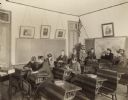
| Date: | 1893 |
|---|---|
| Description: | Male and female students sitting in desks while writing on what appear to be slates. A group sitting in a circle at the back of the room are possibly pract... |
| Date: | 1890 |
|---|---|
| Description: | Letterhead for Moulton, Moran & Co. The logo shows North America and depicts Superior as the center of a hub with spokes going to Russia, to China and Japa... |
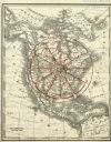
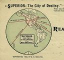
| Date: | 1890 |
|---|---|
| Description: | Rand, McNally map of North America enhanced to show Superior as the center of a wheel. The image was used on the back of stationery from City Improvement C... |
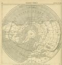
| Date: | 08 12 1865 |
|---|---|
| Description: | A map of the world showing telegraphic systems for encircling the globe. |
| Date: | 1860 |
|---|---|
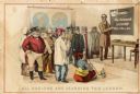
| Description: | African American man, left, map depicting Maryland, Virginia, Delaware and the border of Pennsylvania, right. Key of "DIRECTIONS" in upper right corner. At... |

| Date: | 1887 |
|---|---|
| Description: | A bird's-eye map of Menekaune, Menominee and Marinette. |
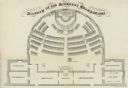
| Date: | 1862 |
|---|---|
| Description: | Diagram and seating chart for the Wisconsin State Assembly. |

| Date: | 1806 |
|---|---|
| Description: | Prehistoric Indian fortification on Hurricane Creek. |
If you didn't find the material you searched for, our Library Reference Staff can help.
Call our reference desk at 608-264-6535 or email us at: