Filter: Categories of Wisconsin Historical Images
Filter: Subject of Maps
Filter: Year of 1800-1899
Filter: Categories of Wisconsin Historical Images
Filter: Subject of Maps
Filter: Year of 1800-1899
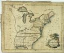
| Date: | 1809 |
|---|---|
| Description: | Embroidered sampler of a map of the United States. |

| Date: | 07 1838 |
|---|---|
| Description: | A map diagram of Indian effigy mounds seven miles east of Blue Mounds in the Wisconsin Territory. |
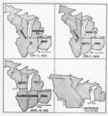
| Date: | 01 11 1805 |
|---|---|
| Description: | Four map illustrations showing the political subdivisions of the Northwest Territory from 1805 through 1834. |

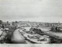
| Date: | 1879 |
|---|---|
| Description: | Bird's-eye view of Wisconsin State University, now the University of Wisconsin-Madison. Vignettes include Ladies Hall, South Dormitory, University Hall, As... |

| Date: | 1867 |
|---|---|
| Description: | Cover of an advertising brochure for E. Ball & Company, "manufacturers of The World mower and reaper, and Tornado thresher." Cover features a color illustr... |

| Date: | 1870 |
|---|---|
| Description: | Cover of advertising catalog for E. Ball & Company, "Manufacturers of The World mower and reaper and Tornado thresher." The cover features a color chromoli... |

| Date: | 1870 |
|---|---|
| Description: | Bird's-eye view of the city of Manitowoc with a population of 5,168 inhabitants as it appears in 1870, the year the village was granted a city charter by t... |
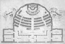
| Date: | 1860 |
|---|---|
| Description: | Floor plan and seating chart for the Assembly for their first meeting in the East Wing of new Wisconsin State Capitol building. After the completion of th... |

| Date: | 1893 |
|---|---|
| Description: | Male and female students read and practice math at the State School for the Deaf as a teacher looks on from the head of the class. |
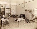
| Date: | 1893 |
|---|---|
| Description: | Interior of the State School for the Blind, perhaps a study or room for recreation. Included in the room are several tables with small models, a piano, and... |

| Date: | 1874 |
|---|---|
| Description: | The Ole Wettlesen family poses in the yard in front of a picket fence with women knitting. Two standing men appear to be examining an unfolded map. The fra... |

| Date: | 08 24 1876 |
|---|---|
| Description: | Hand-drawn plan of the battleground of Huycks. |

| Date: | 03 26 1876 |
|---|---|
| Description: | Hand-drawn map showing the place of Hook's defeat in York County in South Carolina. |

| Date: | 1850 |
|---|---|
| Description: | Lithograph of a map drawn to indicate a mine on land owned by Mineral Point Mining Co. in the lead region of southwestern Wisconsin. |
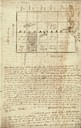
| Date: | 01 12 1844 |
|---|---|
| Description: | Letter from Thomas Steel, Waukesha County physician and farmer, to his father, James Steel, in London, England. It includes a hand-drawn map of Milwaukee C... |

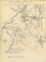
| Date: | 08 10 1862 |
|---|---|
| Description: | A hand-drawn map of the Battle of Wilson's Creek, Springfield, Missouri. Other notes and locations include: "Lyon was killed instantly while heading his tr... |
| Date: | 04 06 1862 |
|---|---|
| Description: | A hand-drawn map of the Battle of Shiloh, Pittsburg Landing, Tennessee. Additional Notes include "Reserve Artillery," "Hospital," "Owl Creek," and "Snake C... |

| Date: | 1836 |
|---|---|
| Description: | The map of Wisconsin City on the Wisconsin River. |
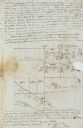
| Date: | 11 26 1846 |
|---|---|
| Description: | A drawing by Thomas Steel of his farm property contained in a letter Steel wrote to his father James Steel. |
If you didn't find the material you searched for, our Library Reference Staff can help.
Call our reference desk at 608-264-6535 or email us at: