 Filter: Categories of Wisconsin Historical Images
Filter: Subject of Maps
Filter: Year of 1800-1899
Filter: Subject of water
Filter: Categories of Wisconsin Historical Images
Filter: Subject of Maps
Filter: Year of 1800-1899
Filter: Subject of water

| Date: | 1890 |
|---|---|
| Description: | This map oriented with north towards the upper right shows sewers, cases of diphtheria and scarlet fever, schools, and public buildings. Lake Wingra is lab... |

| Date: | 1889 |
|---|---|
| Description: | This map lists township and section numbers outside municipality, housing additions and subdivisions and plat owners outside municipality, the Black River,... |

| Date: | 1894 |
|---|---|
| Description: | This map shows automobile routes across the state and into parts of Illinois, Michigan, Minnesota, and Iowa. Cities, counties, Lake Michigan, Lake Superior... |

| Date: | 1881 |
|---|---|
| Description: | This map shows railroads, county boundaries, cities, towns, and waterways with relief shown by hachures. The prime meridians are: Greenwich and Washington.... |

| Date: | 1887 |
|---|---|
| Description: | This map shows railroads, county boundaries, cities, towns, and waterways with relief shown by hachures. The prime meridians are: Greenwich and Washington.... |

| Date: | 1867 |
|---|---|
| Description: | This pen and ink map shows counties outlined in red, cities over 3,000 inhabitants, and county seats. The bottom margin includes a handwritten description ... |

| Date: | 1871 |
|---|---|
| Description: | This maps shows the entire state with an inset map in the lower left corner of Milwaukee. Railroads, roads, canals, the state capital, towns, cities, towns... |

| Date: | 1871 |
|---|---|
| Description: | This map shows the entire state, county boundaries, railroads, cities and towns, Lake Superior, and the extent of surveyed townships with Public Land Surve... |

| Date: | 1892 |
|---|---|
| Description: | This map shows the entire state with railroad routes shown in red, blue, orange, green, brown, pink, green, and black. Also labeled are counties, cities, t... |

| Date: | 1894 |
|---|---|
| Description: | This map shows the entire state with railroad routes shown in red, blue, orange, green, brown, pink, green, and black. Also labeled are counties, cities, t... |

| Date: | 1805 |
|---|---|
| Description: | Map of the United States. It shows the states, cities, towns, Native American land, mountains, lakes, and rivers. Tennessee, Kentucky, and Ohio are labeled... |

| Date: | 1800 |
|---|---|
| Description: | Map of the United States. It shows the states, including Tennessee, cities, towns, Native American land, mountains, lakes, and rivers. Lead mines appear ju... |
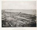
| Date: | 1892 |
|---|---|
| Description: | Bird's-eye view of Cudahy showing stock yards and the Cudahy packing houses. A train runs through the center of the image on the Chicago & Northwestern Rai... |
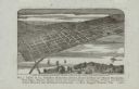
| Date: | 1880 |
|---|---|
| Description: | Bird's-eye map of the city of Madison. Caption reads: "City of Madison — From Park's 'History of Madison, Dane County, and Surrounding Towns.'" The text un... |

| Date: | 1867 |
|---|---|
| Description: | A map and profile map of the railroad line from Omaha to San Francisco. |
If you didn't find the material you searched for, our Library Reference Staff can help.
Call our reference desk at 608-264-6535 or email us at: