 Filter: Categories of Wisconsin Historical Images
Filter: Subject of Maps
Filter: Year of 1800-1899
Filter: Subject of water
Filter: Subject of transportation
Filter: Categories of Wisconsin Historical Images
Filter: Subject of Maps
Filter: Year of 1800-1899
Filter: Subject of water
Filter: Subject of transportation

| Date: | 1879 |
|---|---|
| Description: | Bird's-eye view of Wisconsin State University, now the University of Wisconsin-Madison. Vignettes include Ladies Hall, South Dormitory, University Hall, As... |

| Date: | 1855 |
|---|---|
| Description: | Fox-Wisconsin portage and canal map, when the canal was not yet built. From a map in the office of the city clerk at Portage. "The old trail, the location ... |

| Date: | 1887 |
|---|---|
| Description: | A bird's-eye map of Menekaune, Menominee and Marinette. |

| Date: | 02 1823 |
|---|---|
| Description: | A map featuring the North American expedition from Pittsburgh to the Rocky Mountains led by Edwin James. |

| Date: | 1896 |
|---|---|
| Description: | This map shows railroads, ordinary roads, good roads, township lines, county lines, county boundaries, towns, lakes, and rivers in the southeastern part ... |

| Date: | 1896 |
|---|---|
| Description: | Front cover and interior of banquet menu for Mexican President Porfirio Diaz, to celebrate the construction of a drainage canal between Lake Texcoco and La... |

| Date: | 1864 |
|---|---|
| Description: | Map showing locations of quarries, sink holes, creeks, springs, rivers, houses, forts, and roads. The map appears to have been drawn on to of a plat map of... |

| Date: | 1870 |
|---|---|
| Description: | This map is mostly pencil on paper map but includes latitude and longitude grid in ink. The map covers the Mississippi River from Lake Itasca to the Wiscon... |

| Date: | 1890 |
|---|---|
| Description: | This map oriented with north towards the upper right shows sewers, cases of diphtheria and scarlet fever, schools, and public buildings. Lake Wingra is lab... |

| Date: | 1889 |
|---|---|
| Description: | This map lists township and section numbers outside municipality, housing additions and subdivisions and plat owners outside municipality, the Black River,... |

| Date: | 1894 |
|---|---|
| Description: | This map shows automobile routes across the state and into parts of Illinois, Michigan, Minnesota, and Iowa. Cities, counties, Lake Michigan, Lake Superior... |

| Date: | 1881 |
|---|---|
| Description: | This map shows railroads, county boundaries, cities, towns, and waterways with relief shown by hachures. The prime meridians are: Greenwich and Washington.... |

| Date: | 1887 |
|---|---|
| Description: | This map shows railroads, county boundaries, cities, towns, and waterways with relief shown by hachures. The prime meridians are: Greenwich and Washington.... |

| Date: | 1871 |
|---|---|
| Description: | This maps shows the entire state with an inset map in the lower left corner of Milwaukee. Railroads, roads, canals, the state capital, towns, cities, towns... |

| Date: | 1871 |
|---|---|
| Description: | This map shows the entire state, county boundaries, railroads, cities and towns, Lake Superior, and the extent of surveyed townships with Public Land Surve... |

| Date: | 1892 |
|---|---|
| Description: | This map shows the entire state with railroad routes shown in red, blue, orange, green, brown, pink, green, and black. Also labeled are counties, cities, t... |

| Date: | 1894 |
|---|---|
| Description: | This map shows the entire state with railroad routes shown in red, blue, orange, green, brown, pink, green, and black. Also labeled are counties, cities, t... |
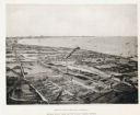
| Date: | 1892 |
|---|---|
| Description: | Bird's-eye view of Cudahy showing stock yards and the Cudahy packing houses. A train runs through the center of the image on the Chicago & Northwestern Rai... |
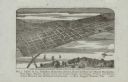
| Date: | 1880 |
|---|---|
| Description: | Bird's-eye map of the city of Madison. Caption reads: "City of Madison — From Park's 'History of Madison, Dane County, and Surrounding Towns.'" The text un... |

| Date: | 1867 |
|---|---|
| Description: | A map and profile map of the railroad line from Omaha to San Francisco. |
If you didn't find the material you searched for, our Library Reference Staff can help.
Call our reference desk at 608-264-6535 or email us at: