Filter: Categories of Wisconsin Historical Images
Filter: Subject of Maps
Filter: Year of 1800-1899
Filter: Subject of cities and towns
Filter: Categories of Wisconsin Historical Images
Filter: Subject of Maps
Filter: Year of 1800-1899
Filter: Subject of cities and towns

| Date: | 1879 |
|---|---|
| Description: | Bird's-eye view of Wisconsin State University, now the University of Wisconsin-Madison. Vignettes include Ladies Hall, South Dormitory, University Hall, As... |

| Date: | 1870 |
|---|---|
| Description: | Bird's-eye view of the city of Manitowoc with a population of 5,168 inhabitants as it appears in 1870, the year the village was granted a city charter by t... |

| Date: | 08 24 1876 |
|---|---|
| Description: | Hand-drawn plan of the battleground of Huycks. |

| Date: | 03 26 1876 |
|---|---|
| Description: | Hand-drawn map showing the place of Hook's defeat in York County in South Carolina. |

| Date: | 08 10 1862 |
|---|---|
| Description: | A hand-drawn map of the Battle of Wilson's Creek, Springfield, Missouri. Other notes and locations include: "Lyon was killed instantly while heading his tr... |

| Date: | 1836 |
|---|---|
| Description: | The map of Wisconsin City on the Wisconsin River. |

| Date: | 12 26 1862 |
|---|---|
| Description: | Handsketched map of the area around Knobs Gap. |

| Date: | 1829 |
|---|---|
| Description: | Map of lead mines operating in Wisconsin. |

| Date: | 1855 |
|---|---|
| Description: | Fox-Wisconsin portage and canal map, when the canal was not yet built. From a map in the office of the city clerk at Portage. "The old trail, the location ... |

| Date: | 1862 |
|---|---|
| Description: | Birds-eye view of a Wisconsin Civil War regiment on parade in Fond du Lac, as drawn by Louis Kurz from the Marr Street Methodist Church. The regiment canno... |

| Date: | 1837 |
|---|---|
| Description: | Copy of N.F. Hyer's original map of Aztalan as published in the Milwaukee Advertiser, February 25, 1837. |
| Date: | 08 1861 |
|---|---|
| Description: | Large-format, illustrated stationery purchased by Rudolph Fine, a member of the 6th Wisconsin Infantry in August, 1861, showing the Capitol (in actuality, ... |
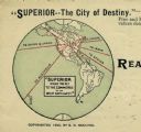
| Date: | 1890 |
|---|---|
| Description: | Letterhead for Moulton, Moran & Co. The logo shows North America and depicts Superior as the center of a hub with spokes going to Russia, to China and Japa... |
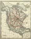
| Date: | 1890 |
|---|---|
| Description: | Rand, McNally map of North America enhanced to show Superior as the center of a wheel. The image was used on the back of stationery from City Improvement C... |

| Date: | 1887 |
|---|---|
| Description: | A bird's-eye map of Menekaune, Menominee and Marinette. |
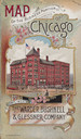
| Date: | 1893 |
|---|---|
| Description: | Front cover of a brochure for Champion Mowers and Binders. Features a color illustration of the office building of the Warder, Bushnell and Glessner Compan... |

| Date: | 1890 |
|---|---|
| Description: | This map shows the congressional districts lines in accordance with the 1890 census. Districts are labeled by number and color. Original caption reads, "Sh... |

| Date: | 09 1894 |
|---|---|
| Description: | This map shows Congregational churches and Home Missionary churches. County boundaries and county seats are also labeled. The original caption reads, "Cong... |
If you didn't find the material you searched for, our Library Reference Staff can help.
Call our reference desk at 608-264-6535 or email us at: