 Filter: Categories of Wisconsin Historical Images
Filter: Subject of Maps
Filter: Subject of water
Filter: Year of 1900-1999
Filter: Year of 1980-1989
Filter: Categories of Wisconsin Historical Images
Filter: Subject of Maps
Filter: Subject of water
Filter: Year of 1900-1999
Filter: Year of 1980-1989

| Date: | 1983 |
|---|---|
| Description: | This map covers Vilas county as well as parts of Iron, Oneida, and Forest counties. Club trails are shown in dotted red lines and state trails are shown in... |

| Date: | 1982 |
|---|---|
| Description: | This map shows the location of major settlement regions for various ethnic groups. Includes a legend in lower left hand corner. Sparse settlement is repres... |
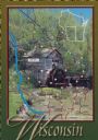
| Date: | 1988 |
|---|---|
| Description: | Text on front, at the foot: "Wisconsin." The color image of Hyde's Mill has an overlay of a map of the southwest corner of Wisconsin inside a red frame. Th... |
If you didn't find the material you searched for, our Library Reference Staff can help.
Call our reference desk at 608-264-6535 or email us at: