 Filter: Categories of Wisconsin Historical Images
Filter: Subject of Maps
Filter: Subject of transportation
Filter: County of Dane
Filter: Categories of Wisconsin Historical Images
Filter: Subject of Maps
Filter: Subject of transportation
Filter: County of Dane

| Date: | 1879 |
|---|---|
| Description: | Bird's-eye view of Wisconsin State University, now the University of Wisconsin-Madison. Vignettes include Ladies Hall, South Dormitory, University Hall, As... |
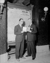
| Date: | 05 27 1941 |
|---|---|
| Description: | Secretary of State Fred R. Zimmerman and Robert "Bob" Brayton, Public Relations Director or the American Automobile Association. They are standing in front... |
| Date: | 09 26 1930 |
|---|---|
| Description: | Crosley radio display at Nelson's at Super Service Station, 220-222 N. Henry Street. |

| Date: | |
|---|---|
| Description: | Poster advertising the Elmside lots for summer homes by Lake Monona. |
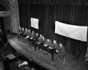
| Date: | 11 25 1947 |
|---|---|
| Description: | Elevated view of eleven men sitting on the stage at Central High School auditorium conducting a hearing on the possibility of putting West Washington Avenu... |
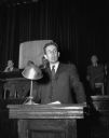
| Date: | 11 25 1947 |
|---|---|
| Description: | Lowell Frautschi, Vice President Frautschi's Furniture Store, speaking at a hearing on the possibility of putting West Washington Avenue under the Chicago,... |

| Date: | 08 1971 |
|---|---|
| Description: | Poster advertising for an event occurring between August 1971 and February 1972 called the "Traffic Experiment," in Madison. Features screen printed silhou... |

| Date: | 1959 |
|---|---|
| Description: | University of Wisconsin-Madison campus. Numbers in circles identify buildings across campus with the building index. Black arrows point out important infor... |
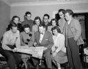
| Date: | 05 02 1950 |
|---|---|
| Description: | Group portrait of young people from the Madison area who will travel together in Europe this summer. Standing, left to right: Helen Olson, Charles Sharpe, ... |
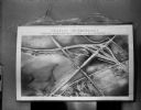
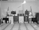
| Date: | 10 11 1950 |
|---|---|
| Description: | Display illustrating the Highway Department's plan for separating highway traffic on Highways 13 and 14 (the Oregon Road) and Highway 12 (the new South Mad... |

| Date: | 03 25 1951 |
|---|---|
| Description: | A large crowd made up of both friends and foes of Motor Vehicle Commissioner Ben L. Marcus attend a legislative committee hearing on his record. The commis... |
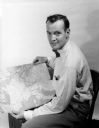
| Date: | 08 31 1953 |
|---|---|
| Description: | Arthur Constable displays the route of his 10-month travel route through Europe and North Africa on a map. |

| Date: | |
|---|---|
| Description: | Back, front, and inside front cover of the menu from The Restaurant at Baron's department store, with "A Historical Map of Madison" focusing on the isthmus... |

| Date: | 06 08 1960 |
|---|---|
| Description: | Blueprint plat of Sunset Hills sub-division. |

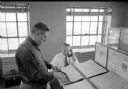
| Date: | 07 01 1954 |
|---|---|
| Description: | Two young people are examining a wall chart depicting traffic lanes, cross walks, and intersections. There are movable adhesive rectangles representing car... |

| Date: | 12 1912 |
|---|---|
| Description: | Sanborn map of Sun Prairie, which includes an index and information about water facilities and the fire department. Includes a small inset map of the State... |

| Date: | 1890 |
|---|---|
| Description: | This map oriented with north towards the upper right shows sewers, cases of diphtheria and scarlet fever, schools, and public buildings. Lake Wingra is lab... |

| Date: | 1913 |
|---|---|
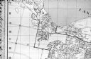
| Description: | This photocopy map shows plots with owners' names, land use both commercial and agricultural, and lot outlines on University land. Lake Mendota is labeled ... |
| Date: | 12 22 1953 |
|---|---|
| Description: | Chief of weather operations, L.A. Joos, is on the telephone, while W.C. Williamson is standing at a slanted desk checking one of several weather maps. They... |
| Date: | 06 1960 |
|---|---|
| Description: | Photograph of street map of the Village of Shorewood Hills and Blackhawk Country Club. Lake Mendota is at the top of the map. |
If you didn't find the material you searched for, our Library Reference Staff can help.
Call our reference desk at 608-264-6535 or email us at: