 Filter: Categories of Wisconsin Historical Images
Filter: Subject of Maps
Filter: Subject of law
Filter: Categories of Wisconsin Historical Images
Filter: Subject of Maps
Filter: Subject of law
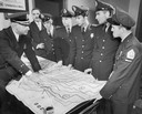
| Date: | 11 21 1956 |
|---|---|
| Description: | Uniformed police officers looking over a laid out map with potential escape routes. |
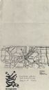
| Date: | 1979 |
|---|---|
| Description: | Map for location of the Magic Picnic, a celebration of the lesbian and gay community, which took place in Brittingham Park. |
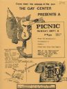
| Date: | 1979 |
|---|---|
| Description: | Poster for picnic presented by the Gay Center at Vilas Park. Includes an image of a fox and telephone. |

| Date: | 10 03 1950 |
|---|---|
| Description: | Madison police chief Bruce Weatherly (left) explains how Madison police fight crimes to visiting internationally-famous Belgian criminal investigator Flour... |

| Date: | 02 15 1952 |
|---|---|
| Description: | Wisconsin Attorney General Vernon W. Thompson sitting at his desk while signing an endorsement of the Madison observance of Crime Prevention Week. The nati... |

| Date: | 12 08 1958 |
|---|---|
| Description: | The newly-formed Madison Business Protective Association, some in uniform and some plainclothed, will move about through commercial areas to check on poten... |
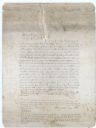
| Date: | 1882 |
|---|---|
| Description: | Note from Albert Pool, surveyor for the village of Dunbarton in Lafayette County, as appears on the reverse of the Village of Dunbarton plat map. Pool cert... |

| Date: | 1963 |
|---|---|
| Description: | State Assemblyman David Obey, Marathon County Sheriff Louis Gianali and Harvey Woodward looking at a map. Harvey Woodward was a veteran of law enforcement ... |

| Date: | 1770 |
|---|---|
| Description: | The south west sheet of a four sheet map of Virginia, showing the counties, mountains, rivers, court houses, a few cities, and mills. A few Plantations ar... |

| Date: | 1795 |
|---|---|
| Description: | Map of Connecticut showing counties, townships, cities, roads, islands, swamps, hills, mountains, lakes, rivers, reefs, and numerous other geographical and... |
If you didn't find the material you searched for, our Library Reference Staff can help.
Call our reference desk at 608-264-6535 or email us at: