 Filter: Categories of Wisconsin Historical Images
Filter: Subject of Maps
Filter: Subject of horses
Filter: Categories of Wisconsin Historical Images
Filter: Subject of Maps
Filter: Subject of horses

| Date: | 1879 |
|---|---|
| Description: | Bird's-eye view of Wisconsin State University, now the University of Wisconsin-Madison. Vignettes include Ladies Hall, South Dormitory, University Hall, As... |
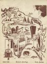
| Date: | 1948 |
|---|---|
| Description: | Holiday card of the history of the State of Wisconsin, 1848-1948. Shows a map of Wisconsin with many historical and themed elements. Image was created by w... |
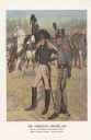
| Date: | 1976 |
|---|---|
| Description: | "A general staff officer stands in the left foreground in the single-breasted blue coat with black herringbone false buttonholes on the chest and cuffs and... |

| Date: | |
|---|---|
| Description: | Back, front, and inside front cover of the menu from The Restaurant at Baron's department store, with "A Historical Map of Madison" focusing on the isthmus... |
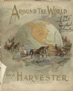
| Date: | 1895 |
|---|---|
| Description: | Front cover of catalog for Deering Harvester Company. The headline reads: "Around the World on a Harvester," and features an illustration of men and women ... |
| Date: | 1895 |
|---|---|
| Description: | Back cover of catalog for Deering Harvester Company. Features an illustration of men, women and children riding on agricultural machinery pulled by horses.... |
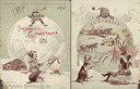
| Date: | 1894 |
|---|---|
| Description: | Front cover featuring a color illustration titled: "Young Canada, 'I wonder what they are doing on the other side,'" and "Merry Christmas." A young boy wea... |
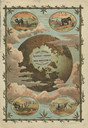
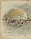
| Date: | 1884 |
|---|---|
| Description: | Front cover of catalog featuring a color illustration of a globe among clouds. Small oval inset illustrations are of farmers working in fields in Africa, A... |

| Date: | 1636 |
|---|---|
| Description: | Map of North America, divided into regions, and showing some rivers, lakes, settlements, cities, mountains, and Native American land. Of the Great Lakes on... |

| Date: | 1740 |
|---|---|
| Description: | Map including the regions and cities of the northern half of North America. Native American land, rivers, lakes, mountains are labeled. Mountains, marshes,... |
| Date: | 1910 |
|---|---|
| Description: | Carl Greene's drawing of a map of The Gang's trip to Winton, titled "We drive to Winton." This map shows a road currently known as the Thirteen Corners Roa... |
If you didn't find the material you searched for, our Library Reference Staff can help.
Call our reference desk at 608-264-6535 or email us at: