 Filter: Categories of Wisconsin Historical Images
Filter: Subject of Lumber
Filter: Subject of railroads
Filter: Categories of Wisconsin Historical Images
Filter: Subject of Lumber
Filter: Subject of railroads
| Date: | |
|---|---|
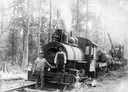
| Description: | Two workers are posing in front of a steam engine carrying logs for an International Harvester sawmill. |
| Date: | 1915 |
|---|---|
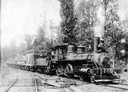
| Description: | Two workers perched on a steam locomotive pulling railroad cars loaded with logs. The coal car bears the name "Deering Southwestern Railway." The railway w... |

| Date: | 1908 |
|---|---|
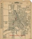
| Description: | Elevated view of the city of Rice Lake with a lumber yard in the foreground, a railroad and Rice Lake at left. Caption reads: "Rice Lake, Wisconsin." |
| Date: | |
|---|---|
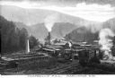
| Description: | Elevated view of Campbell's Mill, which specialized in lumber. Situated in the midst of the forest are smokestacks, railroad tracks, and several buildings.... |
| Date: | |
|---|---|
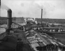
| Description: | Elevated view of the Brooks Scanlon Company, which specialized in lumber. The complex sits on a river. The lumber is lying out on the tops of roofs and in ... |
| Date: | 1920 |
|---|---|
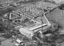
| Description: | Aerial view of the Baldwin Lumber Company, which sits next to a river. The main building consists of two long, rectangular structures that sit perpendicula... |
| Date: | 1900 |
|---|---|
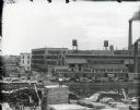
| Description: | View across canal of the McCormick Reaper Works factory, rail yard, and surrounding buildings. Men in the foreground are stacking piles of lumber. After 19... |
| Date: | 1866 |
|---|---|
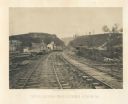
| Description: | View from railroad tracks through the Allatoona Pass. One of the buildings on the left says "Grocery," and piles of lumber are stacked along the sides of t... |
| Date: | |
|---|---|
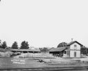
| Description: | Elevated view across railroad tracks of a lumber yard. A two-story building on the right has a sign that says: "Lovejoy & Ringham". There are fences, a sto... |
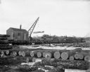
| Date: | 1904 |
|---|---|
| Description: | At Hein's logging camp, a crane mounted on a railroad train lifts logs onto a flatbed railway car. Other logs are stacked on the snowy ground. A number of ... |

| Date: | 1930 |
|---|---|
| Description: | View of William Bonifas Lumber Mill showing the mill buildings, a water tower, "Railroad Crossing" sign, an automobile, lumber stacked on railroad cars, an... |

| Date: | 1972 |
|---|---|
| Description: | This map on 5 sheets features a title page sheet with business directory and shows section numbers, roads, railroads, saw mills, churches, blacksmith shops... |

| Date: | 1872 |
|---|---|
| Description: | This map, which includes eastern Iowa, northern Illinois and a portion of Michigan's Upper peninsula, shows the township survey grid and identifies countie... |

| Date: | 1870 |
|---|---|
| Description: | A map of Iowa County, Wisconsin mounted on cloth that shows the villages of Avoca, Mifflin, Linden, Arena, Helena Station, Highland, Dodgeville, as well as... |

| Date: | 1896 |
|---|---|
| Description: | A map of Iron County, Wisconsin, shows vacant Wisconsin Central Rail Road lands, settlers houses, land sold by Wisconsin Central R.R., schools, churches, s... |

| Date: | 1898 |
|---|---|
| Description: | A map of Iron County, Wisconsin, shows vacant Wisconsin Central Rail Road lands, settlers houses, land sold by Wisconsin Central R.R., schools, churches, s... |

| Date: | |
|---|---|
| Description: | Map of northern Iron County, Wisconsin, shows town sections and railroads in the towns of Saxon, Kimball, and Gurney. It also includes the area of the La P... |

| Date: | 1926 |
|---|---|
| Description: | Relief shown by hachures. Shows local streets, roads, railroads, businesses, Half Moon Lake, Chippewa River, and log reservoir. |

| Date: | 1858 |
|---|---|
| Description: | Map shows township borders, marshes, pine timber, roads, railroads, and mills. The townships are are shown in blue/green, pink, and yellow. The map include... |
| Date: | 1927 |
|---|---|
| Description: | This map shows a plat of city, a numbering system, local streets, railroads, and part of the Rock River. The map is indexed by street name and reads: "Copy... |
If you didn't find the material you searched for, our Library Reference Staff can help.
Call our reference desk at 608-264-6535 or email us at: