 Filter: Categories of Wisconsin Historical Images
Filter: Subject of Lumber
Filter: Subject of michigan, lake
Filter: Categories of Wisconsin Historical Images
Filter: Subject of Lumber
Filter: Subject of michigan, lake

| Date: | 1872 |
|---|---|
| Description: | This map, which includes eastern Iowa, northern Illinois and a portion of Michigan's Upper peninsula, shows the township survey grid and identifies countie... |
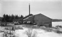
| Date: | 1925 |
|---|---|
| Description: | Logs are stacked beside a sawmill in a winter landscape. The mill has a tall smokestack and stands near the shore. |

| Date: | 1974 |
|---|---|
| Description: | Map of Wisconsin with drawings illustrating historic places and events throughout the state. The Great Seal of the State of Wisconsin appears at the top ri... |
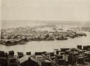
| Date: | 1892 |
|---|---|
| Description: | Elevated view of fishing village on Jones Island, Milwaukee. Several fishing boats are docked along the shoreline. Large piles of lumber are in the foregro... |
If you didn't find the material you searched for, our Library Reference Staff can help.
Call our reference desk at 608-264-6535 or email us at: