 Filter: Categories of Wisconsin Historical Images
Filter: Subject of Lumber
Filter: Subject of lakes
Filter: Categories of Wisconsin Historical Images
Filter: Subject of Lumber
Filter: Subject of lakes
| Date: | |
|---|---|
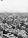
| Description: | View east of buildings and lake from the dome of the Exposition building. Lumber is stacked on the right. |
| Date: | 06 27 1931 |
|---|---|
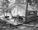
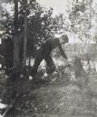
| Description: | Man sawing wood in front of a tent in the woods at the University of Wisconsin Tent Colony. The tent is set up on a wood platform. Also known as Camp Galli... |

| Date: | 1908 |
|---|---|
| Description: | Elevated view of the city of Rice Lake with a lumber yard in the foreground, a railroad and Rice Lake at left. Caption reads: "Rice Lake, Wisconsin." |
| Date: | |
|---|---|
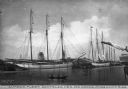
| Description: | View of the fleet owned by Dantzler Lumber Company. Several large sailing vessels are docked, and nearby is a canoe with two passengers. Caption reads: "Lu... |
| Date: | 03 1941 |
|---|---|
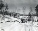
| Description: | An International K-5 truck drives on a snow-covered hillside road in Eagle Lake, Ontario, Canada to deliver cut logs. |

| Date: | 1972 |
|---|---|
| Description: | This map on 5 sheets features a title page sheet with business directory and shows section numbers, roads, railroads, saw mills, churches, blacksmith shops... |

| Date: | 1872 |
|---|---|
| Description: | This map, which includes eastern Iowa, northern Illinois and a portion of Michigan's Upper peninsula, shows the township survey grid and identifies countie... |

| Date: | 1926 |
|---|---|
| Description: | Relief shown by hachures. Shows local streets, roads, railroads, businesses, Half Moon Lake, Chippewa River, and log reservoir. |

| Date: | |
|---|---|
| Description: | A sawmill with workmen sitting outdoors in front of the mill. One man sits on a stack of logs, the other three men stand on a roof which is open sided and ... |
| Date: | 05 1902 |
|---|---|
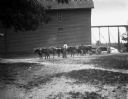
| Description: | View across yard towards six oxen pulling a lumber wagon along a road near a sawmill. A man is standing beside the oxen holding a long whip over his should... |

| Date: | 1974 |
|---|---|
| Description: | Map of Wisconsin with drawings illustrating historic places and events throughout the state. The Great Seal of the State of Wisconsin appears at the top ri... |

| Date: | 1900 |
|---|---|
| Description: | This map shows logging roads, railroads with spur lines, trails, rapids, lumber camps, Indian villages, summer resort, lakes, rivers, and ponds. |

| Date: | 1902 |
|---|---|
| Description: | This map shows townships, land parcels, schools, rivers, lakes, creameries, churches, cemeteries, roads, post offices, town halls, saw mills, roads and sto... |
| Date: | 1900 |
|---|---|
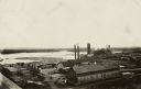
| Description: | Elevated view of a lumber plant, with large stacks of lumber stacked around it. A lake is behind the plant. |

| Date: | 1909 |
|---|---|
| Description: | Elevated view of the damage from the fire. Burned logs are in the foreground, and pieces of burned and broken machinery is among the broken foundation. Men... |
| Date: | 1899 |
|---|---|
| Description: | Wallace Rumsey is building a wooden seat from a fallen log at Lookout Point on the Island at Archibald Lake. Caption reads: "Building the seat on the point... |

| Date: | 08 11 1914 |
|---|---|
| Description: | W.A. Holt, second from the right, and a group of mostly children are playing in Archibald Lake. On the far left, Alfred Holt is giving a thumbs up, with a ... |
If you didn't find the material you searched for, our Library Reference Staff can help.
Call our reference desk at 608-264-6535 or email us at: