 Filter: Categories of Wisconsin Historical Images
Filter: Subject of Lumber
Filter: Subject of church buildings
Filter: Categories of Wisconsin Historical Images
Filter: Subject of Lumber
Filter: Subject of church buildings
| Date: | |
|---|---|
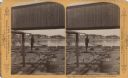
| Description: | Stereograph of a man standing on the back of a raft holding a hand-hewned oar. The raft is passing under a wooden bridge. A town, including a church, are i... |

| Date: | |
|---|---|
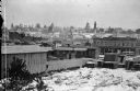
| Description: | A lumberyard at about E. Lincoln Avenue and S. Burrell Street in Bay View, looking west to St. Josaphat's Basilica. |
| Date: | |
|---|---|
| Description: | A view of the lumberyard with the town in the background. |
| Date: | |
|---|---|
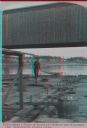
| Description: | Stereograph of a man standing on the back of a raft holding a hand-hewned oar. The raft is passing under a wooden bridge. A town, including a church, are i... |
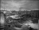
| Date: | 1903 |
|---|---|
| Description: | View from railroads tracks of the wreckage of wooden buildings left behind after a flood. Intact buildings are visible in a skyline in the distance, and pe... |

| Date: | 1937 |
|---|---|
| Description: | A man is loading a piece of lumber onto the back of an International D-2 truck owned by Basley's Good Lumber Company. There appears to be a church steeple ... |

| Date: | 1870 |
|---|---|
| Description: | A map of Iowa County, Wisconsin mounted on cloth that shows the villages of Avoca, Mifflin, Linden, Arena, Helena Station, Highland, Dodgeville, as well as... |

| Date: | 1896 |
|---|---|
| Description: | A map of Iron County, Wisconsin, shows vacant Wisconsin Central Rail Road lands, settlers houses, land sold by Wisconsin Central R.R., schools, churches, s... |

| Date: | 1898 |
|---|---|
| Description: | A map of Iron County, Wisconsin, shows vacant Wisconsin Central Rail Road lands, settlers houses, land sold by Wisconsin Central R.R., schools, churches, s... |

| Date: | 1900 |
|---|---|
| Description: | Elevated view across canal. Along the shoreline are piles of lumber along the shipping dock. Men are working with horse-drawn vehicles among the stacks of ... |

| Date: | 1902 |
|---|---|
| Description: | This map shows townships, land parcels, schools, rivers, lakes, creameries, churches, cemeteries, roads, post offices, town halls, saw mills, roads and sto... |

| Date: | 1889 |
|---|---|
| Description: | This map lists township and section numbers outside municipality, housing additions and subdivisions and plat owners outside municipality, the Black River,... |

| Date: | 1908 |
|---|---|
| Description: | Elevated view of Glidden. The lumber mill is in the foreground. A church and a water tower are on the horizon. |
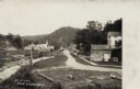
| Date: | 1908 |
|---|---|
| Description: | View of a street with a lumber office and a church on the left, and dwellings on the right. A man and a dog are on the sidewalk. A tree-covered hill is in ... |

| Date: | |
|---|---|
| Description: | Elevated view of several industrial buildings near water, and in the background are fences on a slope, and at the top of the hill are buildings and what ma... |

| Date: | 1907 |
|---|---|
| Description: | Elevated view of Hurley, WI and nearby industrial sites (Scott & Howe Lumber Co. Mill, Ashland Mine). Inventory reads: "Looking west and a little south ove... |
If you didn't find the material you searched for, our Library Reference Staff can help.
Call our reference desk at 608-264-6535 or email us at: