 Filter: Categories of Wisconsin Historical Images
Filter: Subject of Log transportation
Filter: Subject of cities and towns
Filter: Year of 1800-1899
Filter: Categories of Wisconsin Historical Images
Filter: Subject of Log transportation
Filter: Subject of cities and towns
Filter: Year of 1800-1899
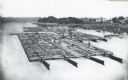
| Date: | 1870 |
|---|---|
| Description: | Elevated view of lumber raft and workers on the Chippewa River. In the background on the right are dwellings. |
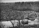
| Date: | 1869 |
|---|---|
| Description: | Elevated view from steep shoreline of a log jam of about 150 million feet of logs, stopped at the piers of Pound, Halbert, and Co., which stood in about 40... |

| Date: | 1886 |
|---|---|
| Description: | Bird's-eye view of Ashland, on the shores of Lake Superior, with insets of The Apostle Islands Chequamagon Bay & Ashland, and Distances from Ashland. |

| Date: | 1870 |
|---|---|
| Description: | Bird's-eye map of Prairie du Sac. |

| Date: | 1870 |
|---|---|
| Description: | Sauk City is the oldest incorporated village in Wisconsin (incorporated in 1854) and also has the oldest organized volunteer fire department in the state, ... |

| Date: | 1874 |
|---|---|
| Description: | Bird's-eye map of Chippewa Falls. |

| Date: | 1872 |
|---|---|
| Description: | Birds-eye drawing of Eau Claire depicts street names and street locations, houses, trees, bridges, piers, canals, railroads, and the Chippewa and Eau Clair... |

| Date: | 1880 |
|---|---|
| Description: | Bird's-eye map over the Mississippi River of Fountain City. Paddle steamers and steamboats are on the river, and bluffs are in the background. |

| Date: | 1871 |
|---|---|
| Description: | Birds eye map of New London depicts street names and street locations, houses, trees, the bridge, Wolf River, and the bayou. At the bottom of the map, a re... |

| Date: | 1883 |
|---|---|
| Description: | Bird's-eye map of Prairie du Sac, Wisconsin with an inset of Clifton. |

| Date: | 1887 |
|---|---|
| Description: | Men on shoreline are returning logs with horses, which have been stranded on a sandbar, to the main channel of the Mississippi River. Beef Slough Company w... |
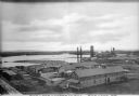
| Date: | 1872 |
|---|---|
| Description: | Elevated view of the Rice Lake Lumber Company Mill, taken from a high vantage point. A formation of logs is in the river, and piles of finished boards are ... |

| Date: | 1887 |
|---|---|
| Description: | Mill workers in the yard at Ramsay & Jones Mill. |

| Date: | 1856 |
|---|---|
| Description: | ". . . The upper Grand Chute was the last of the 'improvements' paintings signed by Brookes and Stevenson. Yet there were two more vital links in the Fox R... |
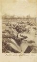
| Date: | 1863 |
|---|---|
| Description: | Carte-de-visite view of the Falls of Saint Anthony and logs caught on rocks in the falls. |
If you didn't find the material you searched for, our Library Reference Staff can help.
Call our reference desk at 608-264-6535 or email us at:


