Filter: Categories of Wisconsin Historical Images
Filter: Subject of Lighthouses
Filter: Year of 1800-1899
Filter: Subject of architecture
Filter: Categories of Wisconsin Historical Images
Filter: Subject of Lighthouses
Filter: Year of 1800-1899
Filter: Subject of architecture

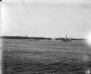
| Date: | 1856 |
|---|---|
| Description: | View looking west from Lake Michigan with several steam ships and sailing vessels in harbor. There is a lighthouse to left of center, along shoreline. |
| Date: | 1897 |
|---|---|
| Description: | Long view of the Minnesota Point lighthouse, built at the entrance to Superior Harbor. It is allegedly the first lighthouse at the head of Lake Superior. |

| Date: | 1856 |
|---|---|
| Description: | The Ludemann's [also spelled Lueddemann] farm had been cultivated since the early 1850s by Mr. Ludemann, "a very pleasant Saxon with his very pleasant wife... |

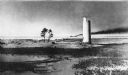
| Date: | 1890 |
|---|---|
| Description: | Second Long Tail Point lighthouse, built in 1859. |
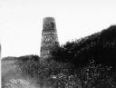
| Date: | 1890 |
|---|---|
| Description: | Long Tail lighthouse. Built in 1847-1848 and abandoned in 1859 when a new frame lighthouse was built nearby. |
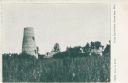
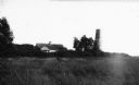
| Date: | 1898 |
|---|---|
| Description: | View across field towards the lighthouse and other buildings among trees. Caption reads: "Long Tail Point, Green Bay, Wis." |
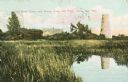
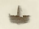
| Date: | 1898 |
|---|---|
| Description: | Caption reads: "Old Stone Tower and House, Long Tail Point, Green Bay, Wis." Water and a marshy area are in the foreground. |

| Date: | 01 04 1862 |
|---|---|
| Description: | Engraving of the city of Superior and Lake Superior, also depicting railroad piers, Minnesota Point, and the steamboat "Star". The engraving appears on a l... |

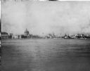
| Date: | 1856 |
|---|---|
| Description: | View of Manitowoc from the north side. |
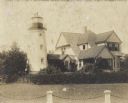
| Date: | 1895 |
|---|---|
| Description: | A chain and posts border the yard of the lighthouse, which is attached to a two-story house. |
| Date: | 1893 |
|---|---|
| Description: | View of the Columbian Exposition grounds from Lake Michigan. |
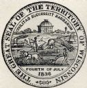
| Date: | 1838 |
|---|---|
| Description: | Territorial seal of Wisconsin. There is a farmer in the foreground plowing behind horses, a Native American apparently heading west, a river steamboat and ... |
| Date: | 07 07 1898 |
|---|---|
| Description: | View across water of Sturgeon Bay. In the far distance are lighthouses, buildings, and barges along the shoreline. |

| Date: | 1896 |
|---|---|
| Description: | This hand-colored map shows counties, county seats, cities, towns, proposed and completed railroads, and U.S. Land Offices. Also included in the map are th... |

| Date: | 1880 |
|---|---|
| Description: | Map of Wisconsin including the eastern portions on Minnesota, Iowa, northern Illinois, and the western most portion of Michigan’s Upper Peninsula, showing ... |

| Date: | 1848 |
|---|---|
| Description: | Wisconsin became the thirtieth state in 1848. Drawn that same year, this map shows township lines, roads, villages, mills, railroads, prairies, swamps, can... |

| Date: | 1896 |
|---|---|
| Description: | This 1896 map of Racine and Kenosha counties, Wisconsin, shows the township and range grid, towns, sections, cities, villages and post offices, roads, rail... |
If you didn't find the material you searched for, our Library Reference Staff can help.
Call our reference desk at 608-264-6535 or email us at: