 Filter: Categories of Wisconsin Historical Images
Filter: Subject of Lighthouses
Filter: Subject of transportation
Filter: Categories of Wisconsin Historical Images
Filter: Subject of Lighthouses
Filter: Subject of transportation

| Date: | 1927 |
|---|---|
| Description: | A switchback path leading to Cap Carbon and the lighthouse perched near the summit of the peninsula. The lighthouse is built on top of a giant rock that pr... |

| Date: | 1941 |
|---|---|
| Description: | Elevated view of Sturgeon Bay in 1900. Sturgeon Bay Bridge spans the bay and several boats are on the water. A lighthouse sits on a small island in the bay... |

| Date: | 1891 |
|---|---|
| Description: | This map shows railroads, electric street railways, block numbers, docks, roads, parks, light houses, selected buildings, and sites for manufacturers. The ... |

| Date: | 1966 |
|---|---|
| Description: | A colored map depiction of Door County, Wisconsin, with pictorial highlights, titled: "Door County — Wisconsin's Air Conditioned Peninsula Playground." |

| Date: | 1962 |
|---|---|
| Description: | Color photograph of a range light built in 1870 to guide ships into the harbor at The Ridges Sanctuary, north of Bailey's Harbor, Door County. The Ridges S... |

| Date: | 01 06 1958 |
|---|---|
| Description: | View from jetty out towards Lake Michigan entrance to Ship Canal. A large tank, streetlamp and buildings are on the left. On the opposite jetty is a lighth... |

| Date: | 01 08 1958 |
|---|---|
| Description: | Elevated view from 8th Street Bridge over the Manitowoc River towards Lake Michigan. There is a lighthouse in the distance. Ice is floating on the water. A... |

| Date: | 01 07 1958 |
|---|---|
| Description: | View from the Second Street bridge over the icy Ahnapee River towards Lake Michigan. A lighthouse is at the end of a jetty in the far background. Boats are... |
| Date: | 07 21 1960 |
|---|---|
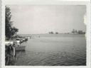
| Description: | View from Oconto looking out into Green Bay Channel, which is often too shallow between the log pilings and lighthouse. Boats and docks are docked along th... |
| Date: | 07 27 1960 |
|---|---|
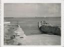
| Description: | View from shoreline at Port Washington south of two ramps within a breakwater. There is a lighthouse in the background. Boats are along a pier on the right... |

| Date: | 12 10 1957 |
|---|---|
| Description: | View of harbor with pilings in the right foreground. There is a lighthouse on breakwaters in the distance. |

| Date: | |
|---|---|
| Description: | Aerial view of harbor. In the foreground is a lighthouse and breakwaters. Bridges cross the harbor, and there are factory and industrial buildings near the... |

| Date: | 07 19 1854 |
|---|---|
| Description: | This map shows the shore in 1844, 1850, and 1852, the length of and proposed additions to the pier. Relief is shown by hachures and depths are shown by sou... |

| Date: | 1905 |
|---|---|
| Description: | This map shows railroads, towns, lights, lights to be established, fog signals, light-vessels, lighted buoys, light-house depots, and light-house reservati... |

| Date: | 1905 |
|---|---|
| Description: | This map shows railroads, towns, lights, lights to be established, fog signals, light-vessels, lighted buoys, light-house depots, and light-house reservati... |

| Date: | 1905 |
|---|---|
| Description: | This map shows railroads, towns, lights, lights to be established, fog signals, light-vessels, lighted buoys, light-house depots, and light-house reservati... |

| Date: | 1908 |
|---|---|
| Description: | This map shows railroads, towns, lights, lights to be established, fog signals, light-vessels, lighted buoys, light-house depots, and light-house reservati... |

| Date: | 1857 |
|---|---|
| Description: | This map shows lot and block numbers, streets, railroad depots, locks, bridges, dams, canals, U.S. light house, college grounds, a steam boat landing, and ... |

| Date: | 04 1926 |
|---|---|
| Description: | This blueprint mostly shows various numbers within the canal and bay. Lake Michigan and Harobor of Refuge are shown along the far right side. Near the harb... |

| Date: | 1938 |
|---|---|
| Description: | This map shows roads, parks, golf courses, airports, beaches, docks and harbors, lighthouses, and buoys within Winnebago County and parts of Waushara, Calu... |
If you didn't find the material you searched for, our Library Reference Staff can help.
Call our reference desk at 608-264-6535 or email us at: