Filter: Categories of Wisconsin Historical Images
Filter: Subject of Landscape
Filter: Subject of fortification
Filter: Categories of Wisconsin Historical Images
Filter: Subject of Landscape
Filter: Subject of fortification
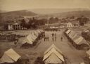
| Date: | 1864 |
|---|---|
| Description: | Elevated view of Battery C, 1st Regiment, Wisconsin Heavy Artillery at Fort Sherman, shown here after the battles of Missionary Ridge and Lookout Mountain.... |

| Date: | 1831 |
|---|---|
| Description: | Drawing of Fort Winnebago (near present-day Portage) that illustrated "Wau-Bun," Juliette Kinzie's memoir of her experiences on the early Wisconsin fronti... |

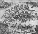
| Date: | 1832 |
|---|---|
| Description: | Black and white engraving showing landscape with Fort Pierre and Indian tipis along the Missouri River. |

| Date: | 1832 |
|---|---|
| Description: | Fort Union, on the Missouri River in Montana. |

| Date: | 1832 |
|---|---|
| Description: | Fort Clark, on the Missouri River, February 1834. |

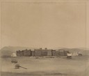
| Date: | 1848 |
|---|---|
| Description: | The first Fort Crawford at Prairie du Chien, with the Mississippi River in the foreground. Although dated 1830, this scene was actually painted by Henry Le... |
| Date: | 1655 |
|---|---|
| Description: | Scene from Laudonnière Expedition in Florida, ca. 1567. |

| Date: | 1655 |
|---|---|
| Description: | Map from Drake Expedition in Florida, ca. 1585. |

| Date: | 1830 |
|---|---|
| Description: | Illustration of Fort Crawford. Caption reads: "Fort Crawford in 1830, Prairie Du Chien, Wis." |
| Date: | 07 25 1849 |
|---|---|
| Description: | Fort Bridger in Wyoming, with wagon parts and teepees, where Wilkins camped for a night; sketched by Wilkins on his 151-day journey from Missouri to Califo... |

| Date: | |
|---|---|
| Description: | Exterior of Fort Donelson with landscape including sparse buildings and trees. |

| Date: | 1831 |
|---|---|
| Description: | Fort Winnebago, a print published in Mrs. John H. Kinzie's Wau-bun (1856). |

| Date: | |
|---|---|
| Description: | Elevated view of Fort Seward from Mount Rippinsky, showing Pyramid Harbor and Davidson Glacier in distance. Caption reads: "Haines and Fort Wm. H. Seward f... |
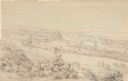
| Date: | 1852 |
|---|---|
| Description: | Landscape view of Fort Snelling, Minnesota Territory from a nearby hill showing the Fort, the Mississippi river, the countryside, farm buildings and tipis.... |
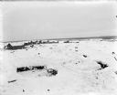
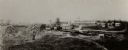
| Date: | 1918 |
|---|---|
| Description: | Trenches constructed for American forces to defend against the Bolshevik "Red" forces. In the background are possibly barracks and other buildings for the ... |

| Date: | 1918 |
|---|---|
| Description: | Looking up at Blockhouse No. 4 while under construction. Trees around the constructions site are being used to provide camouflage. |
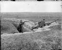
| Date: | 1918 |
|---|---|
| Description: | Two British soldiers posing in a trench. The soldier on the right is manning an air-cooled Vickers light machine gun, and the soldier on the left is holdin... |

| Date: | 1900 |
|---|---|
| Description: | This photostat map shows private claim owners, natural meadows, roads, saw and grist mills, and Fort Howard. The upper right corner includes annotations an... |
If you didn't find the material you searched for, our Library Reference Staff can help.
Call our reference desk at 608-264-6535 or email us at: