 Filter: Categories of Wisconsin Historical Images
Filter: Subject of Landscape
Filter: Subject of bridges
Filter: Categories of Wisconsin Historical Images
Filter: Subject of Landscape
Filter: Subject of bridges

| Date: | 09 1871 |
|---|---|
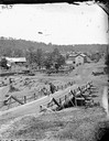
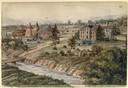
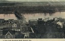
| Description: | Bird's-eye view of Peshtigo, before it was destroyed by fire on the night of October 8, 1871. |
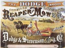
| Date: | 1871 |
|---|---|
| Description: | Advertising poster for the Dodge improved combined self raking reaper and mower featuring a color illustration of a well-dressed farmer on the machine pull... |
| Date: | |
|---|---|
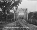
| Description: | View down a metal bridge over the Kickapoo River showing a truck parked on the far side of the bridge. A man and a boy are standing at the rail of the brid... |
| Date: | |
|---|---|
| Description: | View of Kilbourn, with Superior Street bridge in Happy Hollow. Two men are standing on a bridge. Buildings and stacked lumber are in the background. |
| Date: | |
|---|---|
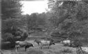
| Description: | Cows near Gates Ravine (Glen Eyrie). There is a bridge over a river in the background. |

| Date: | 05 31 1965 |
|---|---|
| Description: | Elevated view of Evangelical United Brethren church in the vicinity of Highway T. |

| Date: | 1870 |
|---|---|
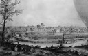
| Description: | Bird's-eye view of the city of Manitowoc with a population of 5,168 inhabitants as it appears in 1870, the year the village was granted a city charter by t... |
| Date: | 1858 |
|---|---|
| Description: | Hölzlhuber located this farm at about three German miles from Stevens Point. The region's soil was quite fertile. A wooden dwelling house stood in the mids... |
| Date: | 1858 |
|---|---|
| Description: | Lithograph view of river with a riverboat on the river, and a family on a hill above the river. There is a wagon or cart on the road below the hill. |
| Date: | 1900 |
|---|---|
| Description: | Bird's-eye view of Cazenovia, with a bridge in the foreground, the town, and in the distance a low hill in the background. Caption reads: "Bird's Eye View... |
| Date: | |
|---|---|
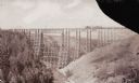
| Description: | Two Medicine Bridge, part of the Gulf and Northern Railroad. |
| Date: | 1900 |
|---|---|
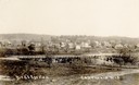
| Description: | Elevated view of Durand. A street in the foreground leads to a bridge that crosses the river. Caption reads: "A View from Morsbach Bluff, Durand, Wis." |

| Date: | 1953 |
|---|---|
| Description: | Aerial view of La Crosse and the Mississippi River. In the foreground is the new bridge as of 1953. |

| Date: | 03 16 1984 |
|---|---|
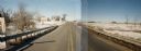
| Description: | A wintertime panoramic view of the bridge on Rainbow Drive, a local road in the Town of Halsey, Marathon County, looking east. |
| Date: | 10 30 1987 |
|---|---|
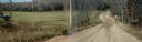
| Description: | Panoramic view of 28th Avenue winding through the Town of Maine in Marathon County. |
| Date: | 03 03 1988 |
|---|---|
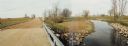
| Description: | View from bridge over Wild Creek on Marathon County Highway M. The creek appears frozen, although in flood. Several farms can be seen in the distance. |
| Date: | 10 26 1986 |
|---|---|
| Description: | Green Elm Road Bridge over the east fork of Hemlock Creek, showing the rocks used to prevent erosion. |

| Date: | 09 1982 |
|---|---|
| Description: | Nollenberg Road Bridge in the Town of Union. |
If you didn't find the material you searched for, our Library Reference Staff can help.
Call our reference desk at 608-264-6535 or email us at:

