 Filter: Categories of Wisconsin Historical Images
Filter: Subject of Landscape
Filter: County of Dane
Filter: Subject of human settlements
Filter: Categories of Wisconsin Historical Images
Filter: Subject of Landscape
Filter: County of Dane
Filter: Subject of human settlements

| Date: | 1873 |
|---|---|
| Description: | Main Street, with its dirt, ruts, cows (and presumably manure), but wide enough for easy hitching of wagons and teams. |

| Date: | 1862 |
|---|---|
| Description: | Camp Randall looking southwest. In April 1861, Governor Alexander Randall asked that the State Agricultural Society fairgrounds be converted into a militar... |
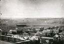
| Date: | 1906 |
|---|---|
| Description: | Elevated view of Camp Randall Field from the top of Bascom Hall, with University Heights in the background. A crowd is in the stands at the stadium, and a ... |

| Date: | 1893 |
|---|---|
| Description: | Back of painting reads: "Madison in June 1837 after photo taken by E.E. Bailey" and "Peck's cabin by Dengel." The Eben Peck cabin was the first house built... |

| Date: | |
|---|---|
| Description: | The Eben Peck cabin was the first house built in Madison. |

| Date: | 1879 |
|---|---|
| Description: | Bird's-eye view of Wisconsin State University, now the University of Wisconsin-Madison. Vignettes include Ladies Hall, South Dormitory, University Hall, As... |

| Date: | 1852 |
|---|---|
| Description: | Pencil drawing of Madison landscape as seen from University Hill. The main street in the center is State Street, and the building with Greek columns in the... |

| Date: | 1852 |
|---|---|
| Description: | Pencil drawing of view overlooking Madison. The sketch looks down North Hamilton Street from the capitol. Rutted, irregular streets and frame houses mark ... |

| Date: | 1875 |
|---|---|
| Description: | Bird's-eye map of Mazomanie. |
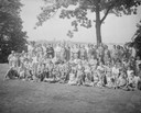
| Date: | 08 03 1941 |
|---|---|
| Description: | Group portrait of Lange family at a reunion in Olin Park, with the Madison skyline in the background. |
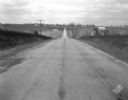
| Date: | 11 08 1928 |
|---|---|
| Description: | Stretch of paved rural highway featuring a proprietary centerline joint, looking towards Mount Horeb from the east. |
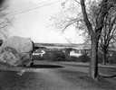
| Date: | 11 20 1926 |
|---|---|
| Description: | View from Observatory Hill of the new Men's Lakeshore dormitories at the University of Wisconsin-Madison, showing Chamberlin Rock in the foreground. The do... |
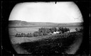
| Date: | 1873 |
|---|---|
| Description: | View across field towards the Amund Rustebakke farm. Twelve haystacks dominate the left and center of the image, and two people are standing on top of the ... |

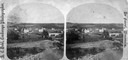
| Date: | 1874 |
|---|---|
| Description: | Distant view of the town from a hill with houses, garden plots, businesses and churches. |
| Date: | 1876 |
|---|---|
| Description: | "One view of the village of Mount Vernon, Wis." a stereograph listed in Dahl's 1877 "Catalogue of Stereoscopic Views." |
| Date: | |
|---|---|
| Description: | View of farmland near Blue Mounds, with possibly property markers horizontal, across the center, and some distant farm houses and a barn. Caption reads: "B... |

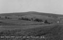
| Date: | 1930 |
|---|---|
| Description: | Remains of the racetrack on the top of Blue Mound. |

| Date: | 05 10 1928 |
|---|---|
| Description: | The Lutheran Church and buildings, seen from Lutheran Church Hill. |
If you didn't find the material you searched for, our Library Reference Staff can help.
Call our reference desk at 608-264-6535 or email us at:

