 Filter: Categories of Wisconsin Historical Images
Filter: Subject of Landscape
Filter: Type of Drawing
Filter: Subject of transportation
Filter: Categories of Wisconsin Historical Images
Filter: Subject of Landscape
Filter: Type of Drawing
Filter: Subject of transportation

| Date: | 10 1852 |
|---|---|
| Description: | Landscape view of the river looking downstream from Fort Snelling, Minnesota Territory. An expanse of placid river water fills the center of the drawing an... |

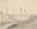
| Date: | 1834 |
|---|---|
| Description: | Peck-a-ton-oka (Pecatonica River) with Rodolf farm in the background. |

| Date: | 1850 |
|---|---|
| Description: | Elevated view of the Lake Superior shoreline, with terraces leading to the beach. A canoe is on the shoreline. |

| Date: | 1872 |
|---|---|
| Description: | The sidewheel packet, Red Wing, in the Mississippi River near Queen's Bluff below Trempealeau, Wisconsin. |

| Date: | 02 21 1874 |
|---|---|
| Description: | African American boatmen run a rapids in a small river boat. |

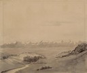
| Date: | 1852 |
|---|---|
| Description: | Pencil drawing of Madison landscape as seen from University Hill. The main street in the center is State Street, and the building with Greek columns in the... |

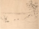
| Date: | 1852 |
|---|---|
| Description: | Pencil drawing of view overlooking Madison. The sketch looks down North Hamilton Street from the capitol. Rutted, irregular streets and frame houses mark ... |

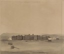
| Date: | 1848 |
|---|---|
| Description: | The first Fort Crawford at Prairie du Chien, with the Mississippi River in the foreground. Although dated 1830, this scene was actually painted by Henry Le... |
| Date: | 08 1852 |
|---|---|
| Description: | Pencil drawing of a lake shoreline. A few trees frame the arc of the shore and steamboats are visible along the distant shore. |
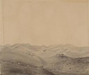
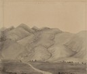
| Date: | 07 12 1849 |
|---|---|
| Description: | Wilkins' first sighting of the Rocky Mountains; sketched by Wilkins on his 151-day journey from Missouri to California on the Overland Trail (also known as... |
| Date: | 07 13 1849 |
|---|---|
| Description: | The trail at Rocky Ridge, showing wagon train, that Wilkins was taking to get to the South Pass in Wyoming; sketched by Wilkins on his 151-day journey from... |
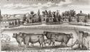
| Date: | 1877 |
|---|---|
| Description: | View of cattle, sheep, and pigs in a pasture on a farm. Two houses are in the distance, and a horse-drawn carriage is moving along the road on the left. Ca... |
| Date: | 05 1849 |
|---|---|
| Description: | Wilkins' wagon procession crossing a creek in Missouri; Sketched by Wilkins on his 151-day journey from Missouri to California on the Overland Trail (also ... |

| Date: | 07 22 1849 |
|---|---|
| Description: | The Ferry at Green River in Wyoming; a single wagon is crossing the river. Sketched by Wilkins on his 151-day journey from Missouri to California on the Ov... |
| Date: | 07 25 1849 |
|---|---|
| Description: | Fort Bridger in Wyoming, with wagon parts and teepees, where Wilkins camped for a night; sketched by Wilkins on his 151-day journey from Missouri to Califo... |
| Date: | 08 01 1849 |
|---|---|
| Description: | Bear Valley in Utah with a wagon train descending the mountains. sketched by Wilkins on his 151-day journey from Missouri to California on the Overland Tra... |

| Date: | 06 13 1849 |
|---|---|
| Description: | Wagon train crossing the South Platte River in Nebraska; Sketched by Wilkins on his 151-day journey from Missouri to California on the Overland Trail (also... |
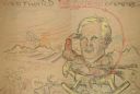
| Date: | 1924 |
|---|---|
| Description: | A hand-drawn cartoon in crayon entitled "Westward The Course Of Empire". It features Frederick Jackson Turner on a rocking horse with a sunset in the backg... |
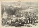
| Date: | 12 17 1862 |
|---|---|
| Description: | Illustration depicting a battle. In the foreground injured soldiers are gathered on and around the porch and yard of a house. In the background are columns... |

| Date: | 1897 |
|---|---|
| Description: | Topographical map of Stanley McCormick's Riven Rock estate in El Montecito, Santa Barbara County, California. The map is identified as a map of a survey co... |
If you didn't find the material you searched for, our Library Reference Staff can help.
Call our reference desk at 608-264-6535 or email us at: