Filter: Categories of Wisconsin Historical Images
Filter: Subject of Landforms
Filter: Year of 1900-1999
Filter: Year of 1950-1959
Filter: Categories of Wisconsin Historical Images
Filter: Subject of Landforms
Filter: Year of 1900-1999
Filter: Year of 1950-1959

| Date: | 1952 |
|---|---|
| Description: | Aerial view of a North Central Airlines DC-3 airplane flying over the Madison isthmus. Clearly visible are the Wisconsin State Capitol, the 1 West Wilson S... |

| Date: | 1958 |
|---|---|
| Description: | Aerial view of contour strip farming with the Obert Olstad farm in foreground. The Carl Backum farm is in the background. |

| Date: | 1955 |
|---|---|
| Description: | Artist's conception of ancient village of Aztalan, fortified with high walls surrounding it. |

| Date: | 1955 |
|---|---|
| Description: | Aerial view of Cross Plains, with countryside surrounding and hills on the horizon. |

| Date: | 1956 |
|---|---|
| Description: | Aerial view looking northeast from a point over the east end of Middleton, showing the west end of Lake Mendota (right mid-ground). Fox Bluff juts into the... |

| Date: | 1955 |
|---|---|
| Description: | An air view of Madison's downtown area with the Wisconsin State Capitol and new State Office Buildings. |

| Date: | 1950 |
|---|---|
| Description: | Aerial view of the Madison isthmus looking north. Caption reads: "Madison Wisconsin — Between Lake Mendota and Lake Monona". |
| Date: | 1955 |
|---|---|
| Description: | Aerial view of Treeland Pines resort on Lake Chippewa. Caption reads: "Air View of Bob Cammack's Treeland Pines Resort; Lake Chippewa, Hayward, Wis." |
| Date: | 1955 |
|---|---|
| Description: | Aerial view of Treeland Pines Resort on Lake Chippewa. Caption reads: "Aerial View of Treeland Pines Resort on Lake Chippewa (The Flowage), Hayward, Wis." |

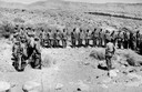
| Date: | 08 1957 |
|---|---|
| Description: | A Red Crescent doctor is holding an Algerian refugee child who survived a French air attack that killed eighteen people. Behind them is a shepherd's daught... |

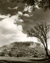
| Date: | 1954 |
|---|---|
| Description: | Raddatz Rockshelter and Natural Bridge, known by archaeologists as 47 SK-5. The bridge is made of sand stone, reaching 35 feet in height, and is the larges... |

| Date: | 11 1951 |
|---|---|
| Description: | Aerial view of US Highway 14 southeast of La Crosse descending into Mormon Coulee. The original caption of the print, which is undated, describes the road ... |

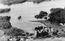
| Date: | 1950 |
|---|---|
| Description: | Elevated view of the bridge across the Mississippi River between Prairie du Chien, Wisconsin and Marquette, Iowa. Caption reads: "Suspension Bridge Between... |
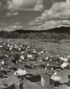
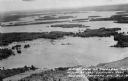
| Date: | 1957 |
|---|---|
| Description: | Lotus beds on Mississippi River in the foreground and middleground. Bluffs are in the background. |
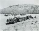
| Date: | 1953 |
|---|---|
| Description: | Men operate three International Harvester earthmovers at the company's Phoenix Proving Grounds. |
If you didn't find the material you searched for, our Library Reference Staff can help.
Call our reference desk at 608-264-6535 or email us at: