 Filter: Categories of Wisconsin Historical Images
Filter: Subject of Landforms
Filter: Year of 1900-1999
Filter: Year of 1940-1949
Filter: Categories of Wisconsin Historical Images
Filter: Subject of Landforms
Filter: Year of 1900-1999
Filter: Year of 1940-1949
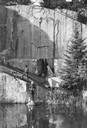
| Date: | 1945 |
|---|---|
| Description: | Two fishermen on rocks alongside the Pike River. |

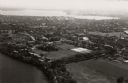
| Date: | 1940 |
|---|---|
| Description: | Aerial view looking east over the center of the city and the University of Wisconsin-Madison campus. |
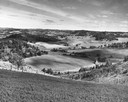
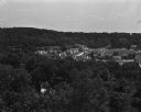
| Date: | 1945 |
|---|---|
| Description: | Elevated view of Trempealeau County, south of Arcadia. |
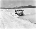
| Date: | 1944 |
|---|---|
| Description: | International truck making its way through the Salduro Marsh of the Bonneville Salt Flats near Wendover on the Utah-Nevada border. The original caption rea... |

| Date: | 1945 |
|---|---|
| Description: | View of the lower campus of the University of Wisconsin-Madison includes Bascom Hill, Wisconsin Historical Society, Memorial Union and the Armory (Red Gym ... |

| Date: | 1941 |
|---|---|
| Description: | Official highway map of Wisconsin, "the playground of the Midwest," showing the state transportation network prior to World War II. |
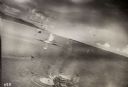
| Date: | 10 22 1943 |
|---|---|
| Description: | View across water of Mushu Island in the distance. There is a ship in the foreground, an airplane above, and the appearance of explosions in the water. |
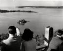
| Date: | 1945 |
|---|---|
| Description: | People on observation tower looking at Sturgeon Bay. |

| Date: | 1945 |
|---|---|
| Description: | An aerial view of the Portage Canal, Fox and Wisconsin Rivers. |
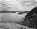
| Date: | 08 03 1946 |
|---|---|
| Description: | View of the Wisconsin River from Cactus Bluff. |

| Date: | 02 06 1948 |
|---|---|
| Description: | Aerial photograph of Madison's west side looking northeast along Speedway Road. Visible are Forest Hill and Resurrection Cemeteries, West High School, Hoyt... |

| Date: | 02 06 1948 |
|---|---|
| Description: | Aerial view of west side, looking south along Glenway Street. Visible are the reservoir, Lake Wingra, Forest Hill and Resurrection Cemetery, Hoyt Park. Maj... |

| Date: | 02 06 1948 |
|---|---|
| Description: | Aerial photograph looking northwest across the reservoir on Glenway Street. Featured are Hoyt and Quarry Parks, Resurrection Cemetery. Major streets are Fr... |

| Date: | 02 06 1948 |
|---|---|
| Description: | Looking north along Glenway Street. Visible are the reservoir, Hoyt and Quarry Parks, Resurrection and Forest Hill Cemeteries, Rentschler Greenhouses, Fore... |

| Date: | 02 06 1948 |
|---|---|
| Description: | Looking southeast across Speedway Road. Visible are the reservoir on Glenway Street, Hoyt Park, Resurrection and Forest Hill cemeteries, Glenway Golf cours... |

| Date: | 02 06 1948 |
|---|---|
| Description: | Looking east along Regent Street with snow on the ground. Visible are Lake Wingra, Monona Bay, railroad causeway across Monona, Lake Mendota, Hoyt Park, We... |

| Date: | 08 06 1948 |
|---|---|
| Description: | Elevated view of west side neighborhood showing East Hill Trailer Camp, 451 N. Midvale Boulevard, at the corner of University Avenue and Midvale Boulevard. |
| Date: | 08 06 1948 |
|---|---|
| Description: | Elevated view of west side neighborhood showing houses to the east of Midvale Boulevard. |

| Date: | 1946 |
|---|---|
| Description: | University of Wisconsin-Madison campus on isthmus, including the Agricultural campus and men's dormitories. Part of Lake Mendota is in the top right corner... |
| Date: | 1946 |
|---|---|
| Description: | View towards southeast of the University of Wisconsin-Madison on isthmus. Lake Mendota is in the lower left corner, and Lake Monona is in the upper portion... |
If you didn't find the material you searched for, our Library Reference Staff can help.
Call our reference desk at 608-264-6535 or email us at: