Filter: Categories of Wisconsin Historical Images
Filter: Subject of Landforms
Filter: Year of 1800-1899
Filter: Categories of Wisconsin Historical Images
Filter: Subject of Landforms
Filter: Year of 1800-1899
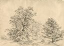
| Date: | 08 1852 |
|---|---|
| Description: | Pencil drawing of Rattlesnake Bluff and the town of Arena from a distance across a plain. A row of buildings runs along the foot of the gently rolling hill... |
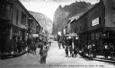
| Date: | 06 01 1892 |
|---|---|
| Description: | View down Main Street featuring crowds of people near the Theatre Comique and other stores and offices. |

| Date: | 1839 |
|---|---|
| Description: | A chart showing the geological cross-section and the height above the surrounding landscape of several locations, such as Platte Mound in Wisconsin, and th... |

| Date: | 1852 |
|---|---|
| Description: | A hand-colored map showing portions of present-day Iron and Vilas counties north of the Manitowish River as part of the Upper Peninsula of Michigan. The Wi... |

| Date: | 1852 |
|---|---|
| Description: | Map shows Wisconsin counties by color and includes rivers, lakes and some cities. This information is also given for eastern Minnesota and northern Illinoi... |

| Date: | 1862 |
|---|---|
| Description: | This map of the southeastern United States shows cities and towns, rail lines, and geographic features such as rivers, mountains, lakes, and swamps. |

| Date: | 1864 |
|---|---|
| Description: | This battlefield map of the Battle of Totopotomoy Creek, also known as the Battle of Bethesda Church, shows the railroads, roads, vegetation and topography... |
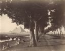
| Date: | 1890 |
|---|---|
| Description: | View down road lined with trees in Egypt. A group of Egyptians are standing and sitting between the trees and the river, and travelers on the road are walk... |
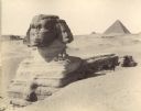
| Date: | 1890 |
|---|---|
| Description: | The Sphinx at Giza in Egypt. Three men are standing or sitting on the shoulder of the Sphinx, and several men are sitting in the shade below with two camel... |
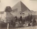
| Date: | 1896 |
|---|---|
| Description: | A group portrait of Violet Lee Dousman (back row, 3rd from left) and her fellow travelers, guides and Egyptians on a trip to Giza, Egypt. Five people are r... |

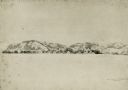
| Date: | 1891 |
|---|---|
| Description: | A deeply rutted dirt road leads to a bridge over a river. Buildings are on both sides of the river. Bluffs and hills with trees are in the background. This... |

| Date: | 1837 |
|---|---|
| Description: | This map shows the townships, roads, trails, natural land forms, vegetation, mill sites and lead and copper deposits in the Wisconsin Territory at the time... |

| Date: | 1867 |
|---|---|
| Description: | This 1867 manuscript map by Increase Lapham shows the topography and geology of the Blue Mounds region in the Town of Brigham in Iowa County and the towns ... |
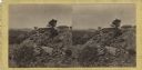
| Date: | 1863 |
|---|---|
| Description: | Stereograph of breast works on a rocky outcropping on the site of the Battle of Gettysburg. A man can be seen standing behind the breast works. He is gazin... |
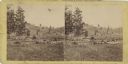
| Date: | 1863 |
|---|---|
| Description: | Stereograph of a scene near the site of the Gettysburg battlefield. Two men sit in a wagon in the center of the image. |
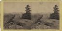
| Date: | 07 1863 |
|---|---|
| Description: | Stereograph of Signal Rock (signal station) on top of Little Round Top at the site of the Gettysburg battlefield. This shows the center of the Federal posi... |

| Date: | 1893 |
|---|---|
| Description: | Bird’s-eye view of Depere looking North. Includes illustrations and an index to points of interest. |
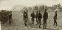
| Date: | 1887 |
|---|---|
| Description: | Wisconsin National Guardsmen standing in two rows for inspection. There are trees and bluffs in the background. |

| Date: | 1887 |
|---|---|
| Description: | Wisconsin National Guard First Light Battery A from Milwaukee at Camp Douglas. A team of horses pulls a small wagon. There are trees and bluffs in the back... |
If you didn't find the material you searched for, our Library Reference Staff can help.
Call our reference desk at 608-264-6535 or email us at: