Filter: Categories of Wisconsin Historical Images
Filter: Subject of Landforms
Filter: Subject of trees
Filter: Categories of Wisconsin Historical Images
Filter: Subject of Landforms
Filter: Subject of trees

| Date: | 1909 |
|---|---|
| Description: | View from the University of Wisconsin service building smokestack of south Madison, including Mills Street, Mound Street, and the Greenbush. Lake Monona is... |
| Date: | |
|---|---|
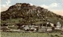
| Description: | View from road towards farm buildings at the base of the bluff. A horse-drawn vehicle is on the rod. Caption reads: "Grand Dad's Bluff, La Crosse, Wis." |

| Date: | 1900 |
|---|---|
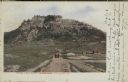
| Description: | Elevated view of La Crosse. Caption reads: "Panorama of La Crosse, Wis. from Grand Dad's Bluff." |
| Date: | 1905 |
|---|---|
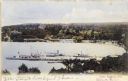
| Description: | Elevated view of Lake Geneva Bay, with assorted homes and hotels, and boats docked at long piers. Caption reads: "Geneva Bay, Lake Geneva, Wis." |

| Date: | 1954 |
|---|---|
| Description: | Raddatz Rockshelter and Natural Bridge, known by archaeologists as 47 SK-5. The bridge is made of sand stone, reaching 35 feet in height, and is the larges... |

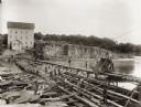
| Date: | 1895 |
|---|---|
| Description: | View of a mill, sluice and dam on Waumandee Creek. The mill was built by John Oschner in 1863. Two products produced by the mill were White Rose Flour and ... |

| Date: | 1960 |
|---|---|
| Description: | Aerial view with docks in the foreground. Caption reads: "Superior, Wisconsin." |

| Date: | 1905 |
|---|---|
| Description: | The view of the Lake Front from across the Mississippi River. Caption reads: "Lake Front at Maiden Rock, Wis." |

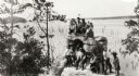
| Date: | 1885 |
|---|---|
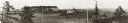
| Description: | Stereograph view of Menomonie. A group of people are sitting on a hill in the foreground overlooking the town. |

| Date: | 1864 |
|---|---|
| Description: | Fort Crawford was decommissioned in 1856, having outlived its usefulness as a frontier post. During the Civil War, however, it functioned as a military ho... |

| Date: | 11 1951 |
|---|---|
| Description: | Aerial view of US Highway 14 southeast of La Crosse descending into Mormon Coulee. The original caption of the print, which is undated, describes the road ... |

| Date: | 1868 |
|---|---|
| Description: | Elevated view up Wisconsin Avenue showing City Hall on the corner at Mifflin Street on the left, with the Post Office to the right. Further down is the Pre... |
| Date: | 1895 |
|---|---|
| Description: | Munger's Mill and dam, with men standing on and around the dam. |
| Date: | 1920 |
|---|---|
| Description: | A group of Indians, probably Ho-Chunk, in traditional costume, posing on and around Demon's Anvil. |
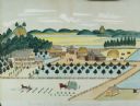
| Date: | 1875 |
|---|---|
| Description: | Seifert's watercolor is fairly large, measuring 27" wide by 21" high, and provides a detailed depiction of a nineteenth century Wisconsin farm. The small s... |

| Date: | 10 1905 |
|---|---|
| Description: | Elevated view from Reservoir Bluff to the east of the town. The bluffs of Iowa can be seen in the distance. |
| Date: | 1925 |
|---|---|
| Description: | Brisbois grave, tomb of Michael Brisbois. A woman is standing behind the graves, looking out to Prairie du Chien and the Mississippi River. |

| Date: | 1915 |
|---|---|
| Description: | Elevated view of Pontoon Bridge. Caption reads: "Largest Pontoon Bridge in the U.S. Scene at the Tri Cities, North and South McGergor and Prairie du Chien.... |
If you didn't find the material you searched for, our Library Reference Staff can help.
Call our reference desk at 608-264-6535 or email us at: