 Filter: Categories of Wisconsin Historical Images
Filter: Subject of Landforms
Filter: Subject of superior, lake
Filter: Categories of Wisconsin Historical Images
Filter: Subject of Landforms
Filter: Subject of superior, lake

| Date: | 1821 |
|---|---|
| Description: | Engraving of the Pictured Rocks shoreline viewed from Lake Superior. |

| Date: | 1910 |
|---|---|
| Description: | Bird's-eye view looking east, with Washburn Harbor at center and Chequamegon Bay in Lake Superior covering most of the upper image. Streets with buildings... |

| Date: | 02 26 1887 |
|---|---|
| Description: | Bird's-eye map of Ashland, and the Apostle Islands in Lake Superior. Caption reads: "Ashland and the Apostle Islands." |
| Date: | |
|---|---|
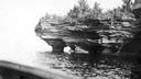
| Description: | Devils Island on Lake Superior, outermost of the Apostle Islands group. There appears to be the edge of a boat in the foreground. |

| Date: | 1941 |
|---|---|
| Description: | Official highway map of Wisconsin, "the playground of the Midwest," showing the state transportation network prior to World War II. |

| Date: | 1960 |
|---|---|
| Description: | Aerial view with docks in the foreground. Caption reads: "Superior, Wisconsin." |

| Date: | 1848 |
|---|---|
| Description: | Immigrant map. |

| Date: | 1670 |
|---|---|
| Description: | This map is in French and shows Lac Tracy ov Superieur (Lake Superior), Baye des Puans (Green Bay), and portions of Lac des Ilinois (Lake Michigan) and Lac... |

| Date: | 1776 |
|---|---|
| Description: | In French: "Partie Occidentale du Canada et septentrionale de la Louisiane avec une partie de la Pensilvanie." A map showing graticule and six European sca... |

| Date: | 1882 |
|---|---|
| Description: | This basic reference map of the state shows natural features, railroads, county seats, and political boundaries against the G.L.O. township and range grid.... |

| Date: | 1868 |
|---|---|
| Description: | Showing the counties, towns and railroads. Partly colored. Scale: 1 inch = 20 miles. |

| Date: | 1857 |
|---|---|
| Description: | A color-coded map of the Lake Superior region, including portions of Wisconsin, Minnesota and Michigan. |

| Date: | 1905 |
|---|---|
| Description: | A reproduction of the Wisconsin portion of Louis Hennepin's 1698 map showing the location of the Ho-Chunk Tribe, the Hurons, the Illinois as well as other ... |

| Date: | 1852 |
|---|---|
| Description: | A hand-colored map showing portions of present-day Iron and Vilas counties north of the Manitowish River as part of the Upper Peninsula of Michigan. The Wi... |

| Date: | 1852 |
|---|---|
| Description: | Map shows Wisconsin counties by color and includes rivers, lakes and some cities. This information is also given for eastern Minnesota and northern Illinoi... |

| Date: | 1938 |
|---|---|
| Description: | View of a house on Nebraska Row on Madeline Island. In the foreground is a flag pole, bench, path, lawn and trees. On the left are docks from the lake shor... |

| Date: | |
|---|---|
| Description: | Exterior of the menu for Paul's Cafe, with a bird's-eye view map of "Washburn's Natural Deep Water Land Locked Harbor," Chequamegon Bay, and the Apostle Is... |

| Date: | |
|---|---|
| Description: | Aerial view of harbor, with shipyards in the foreground and Superior in the background. Caption reads: "Aerial View of Harbor, Superior, Wisconsin." |

| Date: | 1777 |
|---|---|
| Description: | This detailed map of the American colonies shows cities, villages, roads, mountains, lakes, rivers, swamps, counties, state boundaries, and Native American... |

| Date: | 1914 |
|---|---|
| Description: | Elevated view from the lake of the Lake Superior Palisades. |
If you didn't find the material you searched for, our Library Reference Staff can help.
Call our reference desk at 608-264-6535 or email us at: