 Filter: Categories of Wisconsin Historical Images
Filter: Subject of Landforms
Filter: Subject of streams
Filter: Categories of Wisconsin Historical Images
Filter: Subject of Landforms
Filter: Subject of streams

| Date: | 1876 |
|---|---|
| Description: | View of a farmstead with fences, haystacks and a wooden outbuilding. Two men are posing on top of McCord Rock, one of them saluting with his hat. Another ... |
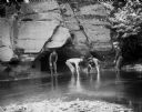
| Date: | |
|---|---|
| Description: | Four young men wade in the water at the base of a rock, one holding a fishing pole. The young men could possibly be the Taylor boys catching minnows in Per... |
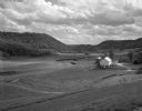
| Date: | 05 30 1962 |
|---|---|
| Description: | A country valley with a winding stream. A farmhouse with barn and silo are on the right. |
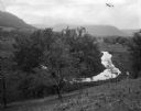
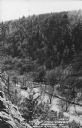
| Date: | 09 06 1964 |
|---|---|
| Description: | View down into small valley with stream. Bluffs are in the distance. |

| Date: | 1930 |
|---|---|
| Description: | Pictorial map of Glacier National Park, Montana and Waterton Lakes National Park, Alberta. Illustrated by Joe Scheurle, it depicts white people, American ... |
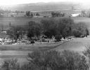
| Date: | 05 30 1967 |
|---|---|
| Description: | View of a parade traveling through a cemetery. Beyond, barns and farmhouses can be seen. |
| Date: | 1920 |
|---|---|
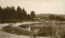
| Description: | View along shoreline towards a rustic foot bridge which crosses the mouth of Fish Creek, which separates the village of Fish Creek from Peninsula State Par... |
| Date: | 1915 |
|---|---|
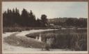
| Description: | A rustic foot bridge over Fish Creek connects Peninsula State Park (foreground) with the village of Fish Creek. The Vits house is at the right end of the b... |
| Date: | 1915 |
|---|---|
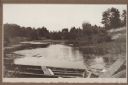
| Description: | A wooden boat forms the foreground of a view of a stream, probably Shivering Sands Creek, and wetlands, with a sand dune on the right. |

| Date: | 1867 |
|---|---|
| Description: | This 1867 manuscript map by Increase Lapham shows the topography and geology of the Blue Mounds region in the Town of Brigham in Iowa County and the towns ... |
| Date: | 10 24 1943 |
|---|---|
| Description: | Robert Doyle's caption for Image ID: 99742 says it best, "The ol' swimmin' hole, South Pacific style. Every afternoon it is filled with shouting soldiers i... |
| Date: | 1910 |
|---|---|
| Description: | A curving, rutted dirt road between a rock wall at Duncan Creek in Irvine Park (probably the "Bear Cage Road"). Caption reads: "Driveway at Duncan Creek in... |

| Date: | 1920 |
|---|---|
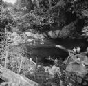
| Description: | A tree-lined rock face next to Duncan Creek in Irvine Park in Chippewa Falls. Caption reads: "A Beautiful Scene in Irvine Park, Chippewa Falls, Wis." |
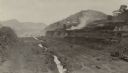
| Date: | 03 1913 |
|---|---|
| Description: | An elevated view of the vast excavation of the Culebra Cut during construction of the Panama Canal. Railroad tracks and a stream are running through the cu... |
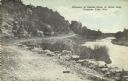
| Date: | 1950 |
|---|---|
| Description: | Text on front reads: "The Old Mill Stream in the Narrows at Rock Springs, Wis." A road and the Narrows Creek run next to each other in an elevated view of ... |

| Date: | 1960 |
|---|---|
| Description: | This standard U.S.G.S. topographic map was annotated by civil engineer and railroad historian James P. Kaysen to show the location of existing and defunct ... |
If you didn't find the material you searched for, our Library Reference Staff can help.
Call our reference desk at 608-264-6535 or email us at:

