 Filter: Categories of Wisconsin Historical Images
Filter: Subject of Landforms
Filter: Subject of persons
Filter: County of Dane
Filter: Subject of human settlements
Filter: Categories of Wisconsin Historical Images
Filter: Subject of Landforms
Filter: Subject of persons
Filter: County of Dane
Filter: Subject of human settlements

| Date: | 1940 |
|---|---|
| Description: | Aerial view looking east over the center of the city and the University of Wisconsin-Madison campus. |
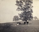
| Date: | 1900 |
|---|---|
| Description: | Fenced-in, the cattle find a grassy pasture of Observatory Hill below Washburn Observatory on the University of Wisconsin-Madison campus. |
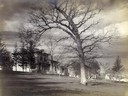
| Date: | 1899 |
|---|---|
| Description: | View of home atop of Observatory Hill on the University of Wisconsin-Madison campus. |

| Date: | 1945 |
|---|---|
| Description: | View of the lower campus of the University of Wisconsin-Madison includes Bascom Hill, Wisconsin Historical Society, Memorial Union and the Armory (Red Gym ... |

| Date: | 1923 |
|---|---|
| Description: | Aerial view of the Wisconsin Historical Society, Science Hall, and Bascom Hall on Bascom Hill on the University of Wisconsin-Madison campus. Lake Mendota i... |
| Date: | 1900 |
|---|---|
| Description: | Elevated view of Observatory Hill on the University of Wisconsin Madison campus of the United States National, Wisconsin State Farm Experiment Station, Pro... |
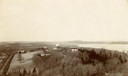
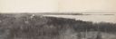
| Date: | 1910 |
|---|---|
| Description: | View from hill looking down at Cross Plains. |

| Date: | 1924 |
|---|---|
| Description: | Aerial view of Madison's Willow Beach towards the University of Wisconsin-Madison campus, downtown Madison, and Lake Monona. |
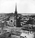
| Date: | |
|---|---|
| Description: | Elevated view of the First Congregational Church and chapel at the corner of North Fairchild Street and West Washington Avenue. The Gates of Heaven Synagog... |

| Date: | 11 19 1970 |
|---|---|
| Description: | Exterior view of the uniquely designed house of Byron Bloomfield at 1010 Edgehill Drive in Shorewood Hills, which is built into the side of a sharp slope. ... |

| Date: | 1909 |
|---|---|
| Description: | View from the University of Wisconsin service building smokestack of south Madison, including Mills Street, Mound Street, and the Greenbush. Lake Monona is... |

| Date: | 1868 |
|---|---|
| Description: | Elevated view up Wisconsin Avenue showing City Hall on the corner at Mifflin Street on the left, with the Post Office to the right. Further down is the Pre... |
| Date: | |
|---|---|
| Description: | Panoramic photograph from top of Bascom Hall facing northwest, showing Picnic Point on the University of Wisconsin campus. Washburn Observatory visible to ... |

| Date: | 02 06 1948 |
|---|---|
| Description: | Looking east along Regent Street with snow on the ground. Visible are Lake Wingra, Monona Bay, railroad causeway across Monona, Lake Mendota, Hoyt Park, We... |

| Date: | |
|---|---|
| Description: | Elevated view looking northwest across Lake Mendota and the isthmus from the Wisconsin State Capitol dome. |

| Date: | 08 06 1948 |
|---|---|
| Description: | Elevated view of west side neighborhood showing East Hill Trailer Camp, 451 N. Midvale Boulevard, at the corner of University Avenue and Midvale Boulevard. |
| Date: | 08 06 1948 |
|---|---|
| Description: | Elevated view of west side neighborhood showing houses to the east of Midvale Boulevard. |

| Date: | 1910 |
|---|---|
| Description: | Aerial View of University of Wisconsin-Madison College of Agriculture. Lake Mendota with Picnic Point is in the background. |

| Date: | 1908 |
|---|---|
| Description: | Aerial View of University of Wisconsin-Madison College of Agriculture. Lake Mendota with Picnic Point is in the background. |

| Date: | 1900 |
|---|---|
| Description: | Aerial View of University of Wisconsin-Madison College of Agriculture. Lake Mendota with Picnic Point is in the background. |
If you didn't find the material you searched for, our Library Reference Staff can help.
Call our reference desk at 608-264-6535 or email us at: