 Filter: Categories of Wisconsin Historical Images
Filter: Subject of Landforms
Filter: Subject of parks
Filter: Categories of Wisconsin Historical Images
Filter: Subject of Landforms
Filter: Subject of parks

| Date: | 1891 |
|---|---|
| Description: | Bird's-eye view of Eau Claire. |

| Date: | 1896 |
|---|---|
| Description: | A portion of John B. Heim's map of the Water Works System of Madison showing the size of the third Wisconsin Capitol (228' x 226') in comparison with the C... |

| Date: | 1892 |
|---|---|
| Description: | Bird's-eye view of Chicago, with ships in the Lake Michigan harbor. |

| Date: | 02 06 1948 |
|---|---|
| Description: | Aerial photograph of Madison's west side looking northeast along Speedway Road. Visible are Forest Hill and Resurrection Cemeteries, West High School, Hoyt... |

| Date: | 02 06 1948 |
|---|---|
| Description: | Aerial view of west side, looking south along Glenway Street. Visible are the reservoir, Lake Wingra, Forest Hill and Resurrection Cemetery, Hoyt Park. Maj... |

| Date: | 02 06 1948 |
|---|---|
| Description: | Aerial photograph looking northwest across the reservoir on Glenway Street. Featured are Hoyt and Quarry Parks, Resurrection Cemetery. Major streets are Fr... |

| Date: | 02 06 1948 |
|---|---|
| Description: | Looking north along Glenway Street. Visible are the reservoir, Hoyt and Quarry Parks, Resurrection and Forest Hill Cemeteries, Rentschler Greenhouses, Fore... |

| Date: | 02 06 1948 |
|---|---|
| Description: | Looking southeast across Speedway Road. Visible are the reservoir on Glenway Street, Hoyt Park, Resurrection and Forest Hill cemeteries, Glenway Golf cours... |
| Date: | 05 14 1899 |
|---|---|
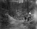
| Description: | Syl and aunt Helen standing on a small rustic wooden bridge in Gully Lake Park surrounded by trees and steep hills. |
| Date: | |
|---|---|
| Description: | Elevated view of a donkey train going up a zig-zag trail along the mountainside in Glacier National Park. |

| Date: | |
|---|---|
| Description: | Group portrait of the National Parks Advisory Board on one of its inspection trips. Sigurd Olson is second from the left. |

| Date: | 1930 |
|---|---|
| Description: | Pictorial map of Glacier National Park, Montana and Waterton Lakes National Park, Alberta. Illustrated by Joe Scheurle, it depicts white people, American ... |

| Date: | |
|---|---|
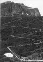
| Description: | Elevated view of Grand Canyon National Park. |
| Date: | |
|---|---|
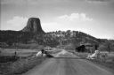
| Description: | View of a highway leading towards Devils Tower. A sign before a cabin on the right reads, "U.S. Department of Interior, Devils Tower, National Monument, Na... |
| Date: | |
|---|---|
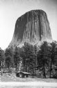
| Description: | View of the distant Devils Tower, a large striated rock formation. A couple stands in the foreground near a small log cabin among trees. |

| Date: | |
|---|---|
| Description: | Elevated view of Devil's Lake and surrounding area from a bluff on the east side of the lake. A man is standing on top of the rock formation near the cente... |
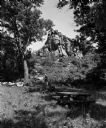
| Date: | 06 27 1954 |
|---|---|
| Description: | Two people walk near a large rock formation in a wooded area with a picnic table in the foreground. The occasion was the opening of a new wayside park loca... |

| Date: | 1909 |
|---|---|
| Description: | Streets, Lake Wingra, Lake Mendota, and Lake Monona are all labelled. Map reads: "The present park system of Madison comprises 150 acres of improved parks,... |
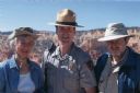
| Date: | 05 2005 |
|---|---|
| Description: | Joan Obey, Ranger Brent McGinn and Congressman David Obey at Bryce Canyon National Park. Canyon walls are in the far background. |

| Date: | 1960 |
|---|---|
| Description: | View across water towards a man, woman, and two children standing on the rock ledge at Cave Point. Lake Michigan is on the right. |
If you didn't find the material you searched for, our Library Reference Staff can help.
Call our reference desk at 608-264-6535 or email us at: