Filter: Categories of Wisconsin Historical Images
Filter: Subject of Landforms
Filter: Subject of landscape
Filter: Categories of Wisconsin Historical Images
Filter: Subject of Landforms
Filter: Subject of landscape

| Date: | 1958 |
|---|---|
| Description: | Aerial view of contour strip farming with the Obert Olstad farm in foreground. The Carl Backum farm is in the background. |
| Date: | 1945 |
|---|---|
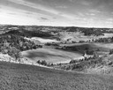
| Description: | Elevated view of Trempealeau County, south of Arcadia. |

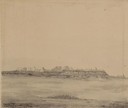
| Date: | 1872 |
|---|---|
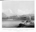
| Description: | The sidewheel packet, Red Wing, in the Mississippi River near Queen's Bluff below Trempealeau, Wisconsin. |

| Date: | 1832 |
|---|---|
| Description: | Junction of the Yellowstone River and the Missouri River. |
| Date: | 1832 |
|---|---|
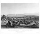
| Description: | Camp of the Gros Ventres along the upper Missouri River, with white travelers passing by in a boat. |

| Date: | 12 01 1962 |
|---|---|
| Description: | A farm road between fields in late sunlight, looking towards Mounds Creek in the vicinity of CTH F. |
| Date: | 1844 |
|---|---|
| Description: | Hunters using rifles to kill buffalo (Plate 11). "This plate represents the familiar mode of procuring meat, practiced by all the voyageurs on the Missou... |
| Date: | 1858 |
|---|---|
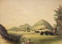
| Description: | Hölzlhuber located this farm at about three German miles from Stevens Point. The region's soil was quite fertile. A wooden dwelling house stood in the mids... |
| Date: | 1902 |
|---|---|
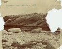
| Description: | A rock formation on Pyramid Lake's Rattlesnake Island. |
| Date: | |
|---|---|
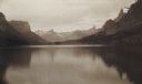
| Description: | The head of Upper St. Mary's Lake with the "Goddess of Liberty" glacier. |

| Date: | |
|---|---|
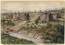
| Description: | Elevated view from bluff of a house in Cassville surrounded by bluffs, trees and farmland. Railroad tracks run between the crops and the trees, and the Mis... |
| Date: | |
|---|---|
| Description: | The Fort Smith Bluffs at the Big Horn Ditch on the Crow Reservation in northeast Wyoming. |
| Date: | |
|---|---|
| Description: | The Fort Smith Bluffs at the Big Horn Ditch on the Crow Reservation in northeast Wyoming. |

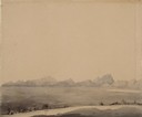
| Date: | 1902 |
|---|---|
| Description: | River with distant hills behind a town. An island is in the foreground. |
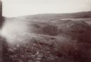
| Date: | 07 10 1849 |
|---|---|
| Description: | The clay hills that were formed by the Sweetwater River in Wyoming; sketched by Wilkins on his 151-day journey from Missouri to California on the Overland ... |

| Date: | 06 20 1849 |
|---|---|
| Description: | Jail and Courthouse Rocks in Nebraska; Sketched by Wilkins on his 151-day journey from Missouri to California on the Overland Trail (also known as the Oreg... |
| Date: | 07 24 1849 |
|---|---|
| Description: | The Clay Bluffs in Wyoming; sketched by Wilkins on his 151-day journey from Missouri to California on the Overland Trail (also known as the Oregon Trail). |
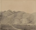
| Date: | 08 01 1849 |
|---|---|
| Description: | Bear Valley in Utah with a wagon train descending the mountains. sketched by Wilkins on his 151-day journey from Missouri to California on the Overland Tra... |
If you didn't find the material you searched for, our Library Reference Staff can help.
Call our reference desk at 608-264-6535 or email us at: