 Filter: Categories of Wisconsin Historical Images
Filter: Subject of Landforms
Filter: Subject of forests and forestry
Filter: Categories of Wisconsin Historical Images
Filter: Subject of Landforms
Filter: Subject of forests and forestry

| Date: | 1902 |
|---|---|
| Description: | River with distant hills behind a town. An island is in the foreground. |
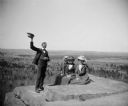
| Date: | |
|---|---|
| Description: | Three women and a man pose at the top of a rock formation overlooking the flat fields and forest below. The three women are sitting while the man stands w... |

| Date: | 05 30 1962 |
|---|---|
| Description: | View down steep hill towards a small lake in a tree-lined valley. |
| Date: | |
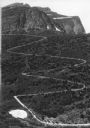
|---|---|
| Description: | Elevated view of a donkey train going up a zig-zag trail along the mountainside in Glacier National Park. |

| Date: | |
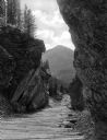
|---|---|
| Description: | Elevated view of Winona Falls Gorge spanned by a small wooden bridge. Someone is resting in the middle of the bridge and a dense stand of pine trees surrou... |
| Date: | |
|---|---|
| Description: | View of a gorge on Mystic Lake with forest covered mountains in the distance. |
| Date: | |
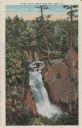
|---|---|
| Description: | View of water streaming down the rock and tree-lined Tyler Falls. A white walk bridge is in the background. |

| Date: | 1971 |
|---|---|
| Description: | A topgraphical map of Cable, Wisconsin showing railroads. |

| Date: | 1971 |
|---|---|
| Description: | A topographical map of Namekagon Lake and the surrounding area. |
| Date: | 1910 |
|---|---|
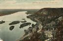
| Description: | Color enhanced aerial view of the village of DeSoto, looking north along the Mississippi River. Caption reads: "Bird's Eye View of the Village of De Soto, ... |
| Date: | 1920 |
|---|---|
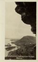
| Description: | Black and white photographic postcard view of De Soto, taken from the cliff south of town, looking north along the Mississippi River. Caption reads: "A Vie... |

| Date: | 1930 |
|---|---|
| Description: | Original map made with watercolor and inkwash. Includes a legend of buildings, roads, natural features and other details of the lodge. Inset at bottom has ... |

| Date: | |
|---|---|
| Description: | Two women are standing with linked arms with their backs to the camera. They are standing on the grass and dirt shore of a lake surrounded by forest. |

| Date: | 1929 |
|---|---|
| Description: | Aerial view of Lake Namakagon, showing the roads that connect Anderson Island (center left), and Juneks Point, Eagle Point, and Paines Island. |

| Date: | |
|---|---|
| Description: | Aerial view of the Pike Chain of Lakes near Iron River, Wisconsin. Caption reads: "Pike Chain of Lakes." Text on back reads: "The ideal vacationland for fi... |

| Date: | 1968 |
|---|---|
| Description: | Aerial view of Cox Hollow Lake in Governor Dodge State Park. |

| Date: | 08 1971 |
|---|---|
| Description: | Aerial view of Madeline Island, and a few of the Apostle Islands in the distance. |

| Date: | |
|---|---|
| Description: | Illustration of a bluff at the Dells, with a woman is sitting on the top near a tree. There are bluffs on the other side of the river in the background.Cap... |
| Date: | |
|---|---|
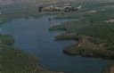
| Description: | Full color aerial view of a lake surrounded by forests. Caption reads: "Boulder Lake." |
If you didn't find the material you searched for, our Library Reference Staff can help.
Call our reference desk at 608-264-6535 or email us at:
