 Filter: Categories of Wisconsin Historical Images
Filter: Subject of Landforms
Filter: Subject of canals
Filter: Categories of Wisconsin Historical Images
Filter: Subject of Landforms
Filter: Subject of canals

| Date: | 1892 |
|---|---|
| Description: | Bird's-eye map of Princeton, with an inset of the Residence of F.T. Yahr. Fox River loops to left of center, with one bridge; thirty-six businesses, reside... |
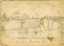
| Date: | 1856 |
|---|---|
| Description: | An original illustration of the lock at Rexford Flats. |

| Date: | 1945 |
|---|---|
| Description: | An aerial view of the Portage Canal, Fox and Wisconsin Rivers. |

| Date: | 1951 |
|---|---|
| Description: | Water depths shown by bathymetric tints and soundings. Relief shown by contours. "Depths in feet." "Aids to navigation corrected to May 4, 1951." On verso:... |

| Date: | 1966 |
|---|---|
| Description: | A colored map depiction of Door County, Wisconsin, with pictorial highlights, titled: "Door County — Wisconsin's Air Conditioned Peninsula Playground." |
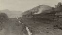
| Date: | 03 1913 |
|---|---|
| Description: | An elevated view of the vast excavation of the Culebra Cut during construction of the Panama Canal. Railroad tracks and a stream are running through the cu... |

| Date: | 07 06 1931 |
|---|---|
| Description: | Text on front reads: "Where Green Bay and Sturgeon Bay Meet, Sturgeon Bay, Wis." Aerial view of Sturgeon Bay showing the only bridge in existence at the ti... |
If you didn't find the material you searched for, our Library Reference Staff can help.
Call our reference desk at 608-264-6535 or email us at: