Filter: Categories of Wisconsin Historical Images
Filter: Subject of Landforms
Filter: Subject of botany
Filter: Year of 1900-1999
Filter: Subject of outdoor photography
Filter: Categories of Wisconsin Historical Images
Filter: Subject of Landforms
Filter: Subject of botany
Filter: Year of 1900-1999
Filter: Subject of outdoor photography
| Date: | 06 1961 |
|---|---|
| Description: | A German shepherd jumps across Stand Rock as a man and child in traditional Indian apparel look on. The man is pointing to the dog. |
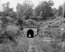
| Date: | 1924 |
|---|---|
| Description: | View from railroad tracks through covered railroad tunnel in hill. A sign on a telephone pole on the right reads: "Private Property / Thoroughfare / Keep O... |
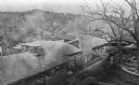
| Date: | 1913 |
|---|---|
| Description: | Elevated view of Taliesin. Taliesin is located in the vicinity of Spring Green. |

| Date: | 12 01 1962 |
|---|---|
| Description: | A farm road between fields in late sunlight, looking towards Mounds Creek in the vicinity of CTH F. |
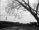
| Date: | 05 05 1931 |
|---|---|
| Description: | View across Lake Mendota towards Picnic Point, framed by a willow tree, and a rowboat pulled up on the shoreline. |

| Date: | 06 30 1926 |
|---|---|
| Description: | View across Observatory Drive, looking down towards the Van Hise dormitories: Adams, Tripp, and Carson Gulley Commons. Picnic Point is in the distance on L... |

| Date: | 12 1925 |
|---|---|
| Description: | Elevated view of the Van Hise Dormitories under construction: Adams, Tripp, Carson Gulley Commons, and a view of Picnic Point, at the University of Wiscons... |
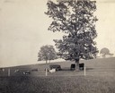
| Date: | 1900 |
|---|---|
| Description: | Fenced-in, the cattle find a grassy pasture of Observatory Hill below Washburn Observatory on the University of Wisconsin-Madison campus. |

| Date: | 1923 |
|---|---|
| Description: | Aerial view of the Wisconsin Historical Society, Science Hall, and Bascom Hall on Bascom Hill on the University of Wisconsin-Madison campus. Lake Mendota i... |
| Date: | 1900 |
|---|---|
| Description: | Elevated view of Observatory Hill on the University of Wisconsin Madison campus of the United States National, Wisconsin State Farm Experiment Station, Pro... |

| Date: | 1900 |
|---|---|
| Description: | Elevated view of the brewery dwarfed by the overhead bluffs. The brewery was built by William Schmitz. George Scheibl ran the brewery from 1899 until his d... |

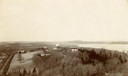
| Date: | 1902 |
|---|---|
| Description: | River with distant hills behind a town. An island is in the foreground. |

| Date: | 1924 |
|---|---|
| Description: | Aerial view of Madison's Willow Beach towards the University of Wisconsin-Madison campus, downtown Madison, and Lake Monona. |
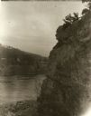
| Date: | 1929 |
|---|---|
| Description: | View of the rock formation known as the "Old Man of the Dalles" in the Interstate State Park near Saint Croix Falls, Wisconsin. The St. Croix River is in t... |

| Date: | 11 19 1970 |
|---|---|
| Description: | Exterior view of the uniquely designed house of Byron Bloomfield at 1010 Edgehill Drive in Shorewood Hills, which is built into the side of a sharp slope. ... |

| Date: | 1909 |
|---|---|
| Description: | View from the University of Wisconsin service building smokestack of south Madison, including Mills Street, Mound Street, and the Greenbush. Lake Monona is... |

| Date: | 1954 |
|---|---|
| Description: | Raddatz Rockshelter and Natural Bridge, known by archaeologists as 47 SK-5. The bridge is made of sand stone, reaching 35 feet in height, and is the larges... |
If you didn't find the material you searched for, our Library Reference Staff can help.
Call our reference desk at 608-264-6535 or email us at: