Visit our other Wisconsin Historical Society websites!
 Filter: Categories of Wisconsin Historical Images
Filter: Subject of Landforms
Filter: Reproduction Rights of For Sale
Filter: Year of 1900-1999
Filter: Categories of Wisconsin Historical Images
Filter: Subject of Landforms
Filter: Reproduction Rights of For Sale
Filter: Year of 1900-1999

| Date: | 1952 |
|---|---|
| Description: | Aerial view of a North Central Airlines DC-3 airplane flying over the Madison isthmus. Clearly visible are the Wisconsin State Capitol, the 1 West Wilson S... |
| Date: | 1945 |
|---|---|
| Description: | Two fishermen on rocks alongside the Pike River. |

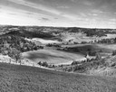
| Date: | 1958 |
|---|---|
| Description: | Aerial view of contour strip farming with the Obert Olstad farm in foreground. The Carl Backum farm is in the background. |
| Date: | 06 1961 |
|---|---|
| Description: | A German shepherd jumps across Stand Rock as a man and child in traditional Indian apparel look on. The man is pointing to the dog. |

| Date: | 1940 |
|---|---|
| Description: | Aerial view looking east over the center of the city and the University of Wisconsin-Madison campus. |
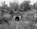
| Date: | 1924 |
|---|---|
| Description: | View from railroad tracks through covered railroad tunnel in hill. A sign on a telephone pole on the right reads: "Private Property / Thoroughfare / Keep O... |

| Date: | 1908 |
|---|---|
| Description: | Colored map showing a panoramic view of Madison in great detail. The Wisconsin State Capitol is located at the center, with Lake Mendota in the background ... |
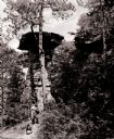
| Date: | 1913 |
|---|---|
| Description: | Elevated view of Taliesin. Taliesin is located in the vicinity of Spring Green. |
| Date: | 1922 |
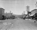
|---|---|
| Description: | View down main street with storefronts on both sides, with large power lines along the sidewalks stretching into the distance, and a hill in the background... |

| Date: | 1908 |
|---|---|
| Description: | A panoramic aerial view of the Isthmus taken from a kite. Lake Mendota is to the right in the background with Picnic Point jutting into the lake. The photo... |
| Date: | 1945 |
|---|---|
| Description: | Elevated view of Trempealeau County, south of Arcadia. |
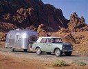
| Date: | 1965 |
|---|---|
| Description: | Color advertising photograph of a couple sightseeing in a 1965 International Scout pickup pulling an Airstream camper in the Nevada hills. |

| Date: | 05 09 1908 |
|---|---|
| Description: | Kite aerial panoramic photograph of the central business district. In the distance is Lake Mendota. The fire damaged Wisconsin State Capitol is in the cent... |

| Date: | 12 01 1962 |
|---|---|
| Description: | A farm road between fields in late sunlight, looking towards Mounds Creek in the vicinity of CTH F. |
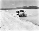
| Date: | 1944 |
|---|---|
| Description: | International truck making its way through the Salduro Marsh of the Bonneville Salt Flats near Wendover on the Utah-Nevada border. The original caption rea... |
| Date: | 05 05 1931 |
|---|---|
| Description: | View across Lake Mendota towards Picnic Point, framed by a willow tree, and a rowboat pulled up on the shoreline. |

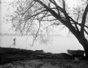
| Date: | 06 30 1926 |
|---|---|
| Description: | View across Observatory Drive, looking down towards the Van Hise dormitories: Adams, Tripp, and Carson Gulley Commons. Picnic Point is in the distance on L... |

| Date: | 12 1925 |
|---|---|
| Description: | Elevated view of the Van Hise Dormitories under construction: Adams, Tripp, Carson Gulley Commons, and a view of Picnic Point, at the University of Wiscons... |

| Date: | 1910 |
|---|---|
| Description: | Bird's-eye view looking east, with Washburn Harbor at center and Chequamegon Bay in Lake Superior covering most of the upper image. Streets with buildings... |
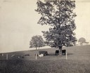
| Date: | 1900 |
|---|---|
| Description: | Fenced-in, the cattle find a grassy pasture of Observatory Hill below Washburn Observatory on the University of Wisconsin-Madison campus. |
If you didn't find the material you searched for, our Library Reference Staff can help.
Call our reference desk at 608-264-6535 or email us at: