Visit our other Wisconsin Historical Society websites!
 Filter: Categories of Wisconsin Historical Images
Filter: Subject of Landforms
Filter: Reproduction Rights of For Sale
Filter: Categories of Wisconsin Historical Images
Filter: Subject of Landforms
Filter: Reproduction Rights of For Sale
| Date: | 1858 |
|---|---|
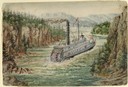
| Description: | In August 1858, Hölzlhuber traveled up the St. Croix River to Stillwater, Minnesota, on the steamship Winona. He noted the upper Mississippi's tribu... |
| Date: | 1864 |
|---|---|
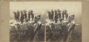
| Description: | Albumen stereograph of the Union Army brass band posed and playing atop Lookout Point. The Tennessee River is in the background. |

| Date: | 1952 |
|---|---|
| Description: | Aerial view of a North Central Airlines DC-3 airplane flying over the Madison isthmus. Clearly visible are the Wisconsin State Capitol, the 1 West Wilson S... |
| Date: | 1945 |
|---|---|
| Description: | Two fishermen on rocks alongside the Pike River. |

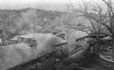
| Date: | 1958 |
|---|---|
| Description: | Aerial view of contour strip farming with the Obert Olstad farm in foreground. The Carl Backum farm is in the background. |
| Date: | 06 1961 |
|---|---|
| Description: | A German shepherd jumps across Stand Rock as a man and child in traditional Indian apparel look on. The man is pointing to the dog. |

| Date: | 1940 |
|---|---|
| Description: | Aerial view looking east over the center of the city and the University of Wisconsin-Madison campus. |
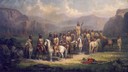
| Date: | 06 1876 |
|---|---|
| Description: | Sioux Chiefs at Little Big Horn. |
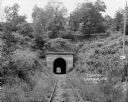
| Date: | 1924 |
|---|---|
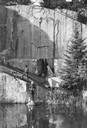
| Description: | View from railroad tracks through covered railroad tunnel in hill. A sign on a telephone pole on the right reads: "Private Property / Thoroughfare / Keep O... |

| Date: | 1908 |
|---|---|
| Description: | Colored map showing a panoramic view of Madison in great detail. The Wisconsin State Capitol is located at the center, with Lake Mendota in the background ... |

| Date: | 1835 |
|---|---|
| Description: | Little Lake Butte Des Morts just north of Lake Winnebago where Governor Lewis Cass of Michigan, and Thomas McKenney, head of the Bureau of Indian Affairs (... |
| Date: | 1913 |
|---|---|
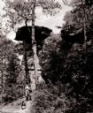
| Description: | Elevated view of Taliesin. Taliesin is located in the vicinity of Spring Green. |
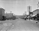
| Date: | 1922 |
|---|---|
| Description: | View down main street with storefronts on both sides, with large power lines along the sidewalks stretching into the distance, and a hill in the background... |
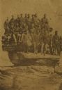
| Date: | 04 20 1864 |
|---|---|
| Description: | Company D, Twenty-first Wisconsin Volunteer Infantry. Top row (left to right): John Buboltz, Spencer Orlup, J. Henry Otto, Lyman C. Wait, Andrew Jackson, W... |

| Date: | 1908 |
|---|---|
| Description: | A panoramic aerial view of the Isthmus taken from a kite. Lake Mendota is to the right in the background with Picnic Point jutting into the lake. The photo... |

| Date: | |
|---|---|
| Description: | View looking out from under Overhanging Rock toward Black Hawk's Leap. |
| Date: | 1875 |
|---|---|
| Description: | View from a distance of a farm in a valley owned by Alex(ander?) Smith. There is a wooden fence in the foreground surrounding the farm. |

| Date: | 1821 |
|---|---|
| Description: | Engraving of the Pictured Rocks shoreline viewed from Lake Superior. |
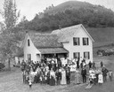
| Date: | 1890 |
|---|---|
| Description: | People attending a wedding reception, posing outdoors. They are standing in front of a modern house that has a log cabin attached to the back. In the backg... |
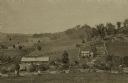
| Date: | 1945 |
|---|---|
| Description: | Elevated view of Trempealeau County, south of Arcadia. |
If you didn't find the material you searched for, our Library Reference Staff can help.
Call our reference desk at 608-264-6535 or email us at: