Filter: Categories of Wisconsin Historical Images
Filter: Subject of Land use, Urban
Filter: Community of Madison
Filter: Categories of Wisconsin Historical Images
Filter: Subject of Land use, Urban
Filter: Community of Madison

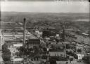
| Date: | 1930 |
|---|---|
| Description: | Aerial view of the Wisconsin State Capitol, the surrounding businesses, and Lake Monona. |

| Date: | 1930 |
|---|---|
| Description: | Aerial view of the Wisconsin State Capitol and the surrounding businesses. |

| Date: | 1930 |
|---|---|
| Description: | Aerial view of the Wisconsin State Capitol and the surrounding businesses. |

| Date: | 1930 |
|---|---|
| Description: | Aerial view of the city with horizon in the far distance. Includes the Wisconsin State Capitol, businesses, Lake Monona, and the surrounding neighborhoods. |

| Date: | 1930 |
|---|---|
| Description: | Aerial view of the University of Wisconsin-Madison campus including Camp Randall Stadium, the Wisconsin State Capitol, and both Lake Mendota and Lake Monon... |
| Date: | 1955 |
|---|---|
| Description: | West Doty Street, from Monona Avenue looking toward South Carroll Street, showing the back side of Madison Newspapers, Inc. The building was added on to in... |

| Date: | 1930 |
|---|---|
| Description: | Aerial view of near west side, including West High School, the Forest Products Laboratory, Lake Mendota, and Picnic Point. |
| Date: | 1932 |
|---|---|
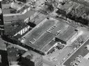
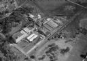
| Description: | Aerial view of the Oscar Mayer Meat Packing Plant and the surrounding neighborhoods on the east side. |

| Date: | 02 08 1970 |
|---|---|
| Description: | Chicago, Milwaukee, St. Paul & Pacific Railroad tracks running down the middle of East Wilson Street from South Baldwin Street to Dickinson Street. |
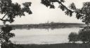
| Date: | 1900 |
|---|---|
| Description: | Madison skyline, including the Wisconsin State Capitol, from the south shore of Lake Monona. |
| Date: | 1917 |
|---|---|
| Description: | View from Capitol dome east to Third Lake Ridge District. Power plant is visible at center. Lake Monona is on the right. |
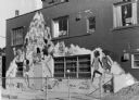
| Date: | 03 20 1977 |
|---|---|
| Description: | A mural painted on the side of the Red Caboose Day Care Center at 654 Williamson Street. Images in the mural include children playing, grasshoppers, a turt... |
| Date: | 1859 |
|---|---|
| Description: | Madison's Pinckney Street, with the Capitol Park in the foreground and Farwell's octagon house and Lake Monona in the distance. This view has been various... |

| Date: | 1917 |
|---|---|
| Description: | The Lake Forest community plan, a model community that was planned for the site where the University of Wisconsin Arboretum now stands. |

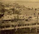
| Date: | 1868 |
|---|---|
| Description: | Elevated view of the intersection of Main and Carroll Streets, showing the home of Nathaniel Dean (where the Inn on the Park Hotel is now located), and St.... |

| Date: | 07 01 1836 |
|---|---|
| Description: | Original plat map of the town of Madison on the four lakes. |
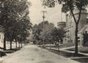
| Date: | 1905 |
|---|---|
| Description: | Langdon Street and the lower campus of the University of Wisconsin, including the Armory (Red Gym or Old Red). |
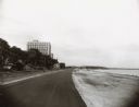
| Date: | 1957 |
|---|---|
| Description: | Law Park along Lake Monona, after filling in the shoreline to construct a road and parking lot. This is the current site of the Monona Terrace. |
If you didn't find the material you searched for, our Library Reference Staff can help.
Call our reference desk at 608-264-6535 or email us at: