 Filter: Categories of Wisconsin Historical Images
Filter: Subject of Land use, Urban
Filter: Creator Name of Vinje, Arthur M., 1888-1972
Filter: Categories of Wisconsin Historical Images
Filter: Subject of Land use, Urban
Filter: Creator Name of Vinje, Arthur M., 1888-1972
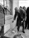
| Date: | 05 14 1950 |
|---|---|
| Description: | President Harry S. Truman visited Madison to be present at the laying of the cornerstone for the CUNA's Filene House, 1617 Sherman Avenue. He is pictured ... |
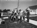
| Date: | 04 16 1951 |
|---|---|
| Description: | A group of East Siders are watching as another of the thousands of trees which have been planted under the sponsorship of the East Side Business Men's Asso... |

| Date: | 06 17 1952 |
|---|---|
| Description: | Aerial photos probably of Madison, looking north east from intersection of Nakoma Road (Hwy. 18-151) and West Beltline Highway (Hwy. 12-18) toward Isthmus,... |

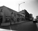
| Date: | 08 07 1952 |
|---|---|
| Description: | View of a filled parking lot at Block 53, 300 block of West Mifflin Street. |

| Date: | 08 07 1952 |
|---|---|
| Description: | View of a filled parking lot at Block 53, 300 block of West Mifflin Street. The Endres Electric sign is visible. |

| Date: | 07 23 1953 |
|---|---|
| Description: | Elevated long shot view of 13 young golfers practicing their driving stance as the golf pro is looking on. |

| Date: | 12 23 1953 |
|---|---|
| Description: | Aerial view of Crawford Heights looking northwest across Nakoma Road. The photograph shows Nakoma Road, the West Beltline, Cherokee School, and Midvale Bou... |

| Date: | 12 23 1953 |
|---|---|
| Description: | Aerial view of Crawford Heights looking north along Midvale Boulevard. The photograph shows Nakoma Road, the West Beltline, Cherokee School, and Midvale Bo... |

| Date: | 12 23 1953 |
|---|---|
| Description: | Aerial view of Crawford Heights looking northeast along Nakoma Road, across the West Beltline. The photograph shows Midvale Boulevard and Lake Mendota appe... |

| Date: | 12 22 1953 |
|---|---|
| Description: | Aerial photograph of Crawford Heights looking west along the West Beltline. The photograph shows Nakoma Road, Midvale Boulevard, Cherokee School, and the A... |

| Date: | 12 23 1953 |
|---|---|
| Description: | Aerial view of Crawford Heights looking west along the West Beltline. The photograph shows Nakoma Road, Midvale Boulevard, Cherokee School, and the Arboret... |

| Date: | 12 23 1953 |
|---|---|
| Description: | Aerial view of Crawford Heights looking north by northwest along the West Beltline with Cherokee School and the Arboretum at lower right and Lake Mendota a... |

| Date: | 10 11 1954 |
|---|---|
| Description: | Rows of maple trees, turning color, line the 2600 block of Regent Street. The photograph looks east and part of Resurrection cemetery is visible at right. |
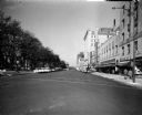
| Date: | 10 28 1956 |
|---|---|
| Description: | View of East Main Street on the Capitol Square, one of four images making up a panorama of the southeast side of the Capitol Square. The S.S. Kresge Co. bu... |
| Date: | 10 28 1956 |
|---|---|
| Description: | View of the South Pinckney Street side of the Capitol Square, one of four images making up a panorama of the southeast side of the Capitol Square. Pictured... |

| Date: | 06 16 1958 |
|---|---|
| Description: | Leaders in the Madison metropolitan area met to learn more about the Madison Improvement Corporation whose purpose is to buy and develop land for the expan... |

| Date: | 06 16 1958 |
|---|---|
| Description: | Leaders in the Madison metropolitan area met to learn more about the Madison Improvement Corporation, whose purpose is to buy and develop land for the expa... |

| Date: | 06 16 1958 |
|---|---|
| Description: | Leaders in the Madison metropolitan area met to learn more about the Madison Improvement Corporation whose purpose is to buy and develop land for the expan... |

| Date: | 06 16 1958 |
|---|---|
| Description: | Leaders in the Madison metropolitan area met to learn more about the Madison Improvement Corporation whose purpose is to buy and develop land for the expan... |

| Date: | 02 02 1960 |
|---|---|
| Description: | The Madison Redevelopment Authority joined in the city's program of locating and permanently marking land survey corners in the Madison area. Here they mar... |
If you didn't find the material you searched for, our Library Reference Staff can help.
Call our reference desk at 608-264-6535 or email us at: