 Filter: Categories of Wisconsin Historical Images
Filter: Subject of Land use, Rural
Filter: Categories of Wisconsin Historical Images
Filter: Subject of Land use, Rural
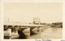
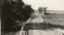
| Date: | 1925 |
|---|---|
| Description: | View across water along the right side of the Sauk City bridge, erected in 1922 to replace an old toll bridge. tree-covered hills are on the opposite shore... |
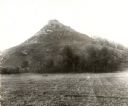
| Date: | 1896 |
|---|---|
| Description: | View of Black Hawk Bluff, site of the Battle of Wisconsin Heights in the Black Hawk War. |

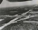
| Date: | 1998 |
|---|---|
| Description: | North-facing aerial view of the interchange between Interstates 39/90 and US Routes 12/18 in the southeast of Madison. Femrite Drive can be seen passing be... |
| Date: | 1960 |
|---|---|
| Description: | Aerial view of the intersection of the interstate highway with USH 12 between Baraboo and Lake Delton with the initial grading largely completed. |

| Date: | 1960 |
|---|---|
| Description: | Aerial view of the construction of the interstate highway near Mirror Lake, showing only the early stages of the bridge construction. |
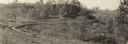
| Date: | 1912 |
|---|---|
| Description: | View down hill toward two cars passing each other along the Lincoln Highway near Bedford, Pennsylvania. The Lincoln Highway was conceived in 1912 by Carl F... |
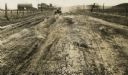
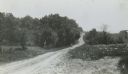
| Date: | 1918 |
|---|---|
| Description: | Amery Road near New Richmond. The photograph was taken by the Wisconsin Good Roads Association probably as an illustration of the kind of improved roads t... |
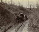
| Date: | 1898 |
|---|---|
| Description: | Two men attempt to move a buggy mired in the mud on a rutted, dirt road. One man is steadying the horse and his hat is laying in the middle of the road. Th... |
| Date: | 1926 |
|---|---|
| Description: | Car on a dirt highway west of Hustler. The highway is U.S. 12 and 16. |

| Date: | |
|---|---|
| Description: | Rural dirt road in the town of Antigo. Houses are in the distance. |
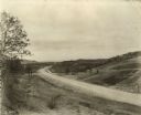
| Date: | 1916 |
|---|---|
| Description: | Panoramic view of the section of State Highway 115 in Richland County known as Muscoda-Richland Center Road. Grading and improvement of this hilly section... |
| Date: | 1936 |
|---|---|
| Description: | Roadimprovements along the portion of US Highway 16 known as the La Crosse-West Salem Road. At the time, this road represented the ultimate in modern high... |
| Date: | |
|---|---|
| Description: | Motorcyclist driving down a rural dirt road. |
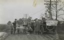
| Date: | |
|---|---|
| Description: | Men, motorcycles and a car stopped on a rural dirt road. A sign on the back of the car reads "Milwaukee Journal Motorcycle Tour Press Car". |
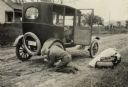
| Date: | 1923 |
|---|---|
| Description: | Tire blowouts were a frequent hazard of early automobile travel. |

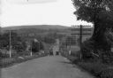
| Date: | 1910 |
|---|---|
| Description: | Photographic postcard showing a man driving an early open automobile with a railroad overpass behind him. Caption reads: "Out for a Spin, Bonduel, Wis." |

| Date: | 08 11 1944 |
|---|---|
| Description: | Six Russian representatives of the Soviet government observing a new McCormick-Deering Company Model 50-T hay baler at the Bowman Dairy Farm on Fish Hatche... |
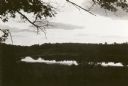
| Date: | 1923 |
|---|---|
| Description: | View of Fountain Lake (officially known as Ennis Lake), John Muir's boyhood home near Montello. The area is now a 125-acre State Natural Area. Fountain Lak... |
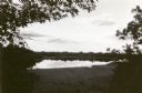
| Date: | 1923 |
|---|---|
| Description: | View of Fountain Lake (officially known as Ennis Lake), John Muir's boyhood home near Montello. The area is now a 125-acre State Natural Area. Fountain Lak... |
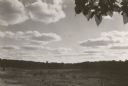
| Date: | 1923 |
|---|---|
| Description: | View of Fountain Lake (officially known as Ennis Lake), John Muir's boyhood home near Montello. The area is now a 125-acre State Natural Area. Fountain Lak... |
If you didn't find the material you searched for, our Library Reference Staff can help.
Call our reference desk at 608-264-6535 or email us at: