 Filter: Categories of Wisconsin Historical Images
Filter: Subject of Land use, Rural
Filter: Year of 1800-1899
Filter: Categories of Wisconsin Historical Images
Filter: Subject of Land use, Rural
Filter: Year of 1800-1899

| Date: | 1895 |
|---|---|
| Description: | A group of purebred Hampshire Down ewes stand in a field of rapeseed. In the background behind fences are more fields, and a group of horses grazing. There... |

| Date: | 1895 |
|---|---|
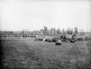
| Description: | Steers, possibly a shorthorn variety, graze on a fenced-in pasture on the farm of Chas. Silkworth six miles from Augusta. Trees and a large house stand on ... |

| Date: | 1895 |
|---|---|
| Description: | A view of purebred Shropshire ewes grouped together in a fenced-in pasture on the stock farm of Andrew Tainter. |
| Date: | 07 10 1895 |
|---|---|
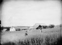
| Description: | Two men stand in a vast field of oats on the farm of Fred Ashbrenner in Siegler. A frame farmhouse, farm buildings, and trees are in the background. |
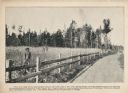
| Date: | 10 12 1895 |
|---|---|
| Description: | Forty-nine hogs at feeding time on the farm of William Miller. The hogs are eleven-months old and weigh approximately 260 lbs each. A wagon and horse team ... |
| Date: | 1895 |
|---|---|
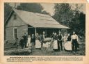
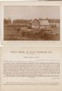
| Description: | A promotional card displaying a group of thirteen people outside their new home in Northern Wisconsin. The caption bellow the photograph reads, "These pe... |
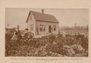
| Date: | 09 04 1895 |
|---|---|
| Description: | A promotional card depicting Oswald Scheller and his family on their farm in northern Wisconsin. The caption below the image reads: "Field of potatoes on... |
| Date: | 1895 |
|---|---|
| Description: | The front (top) and back (bottom) of a promotional card created to attract farmers to the agricultural land in northern Wisconsin. The card features an ima... |

| Date: | 1895 |
|---|---|
| Description: | A promotional cards created to attract farmers to the agricultural land in northern Wisconsin. The image depicts Conrad Flicker and his family standing in ... |
| Date: | 1895 |
|---|---|
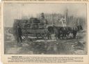
| Description: | A promotional card advertising the large amounts of hay that can be growth in northern Wisconsin. The image shows three men posing on and beside a wagon ca... |
| Date: | 1895 |
|---|---|
| Description: | The front (top) and back (bottom) of a promotional cards showing the plentiful corn crops of John Carstens, created to attract farmers to the agricultural ... |
| Date: | 07 1897 |
|---|---|
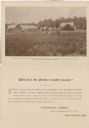
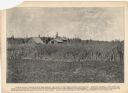
| Description: | Promotional card depicting the prosperous farming in northern Wisconsin. Caption: "Here is shown a mixed crop of peas and rye, the clover in the foregrou... |
| Date: | 07 1897 |
|---|---|
| Description: | A promotional card displaying a man in overalls standing by his large rye crops, near the road. The caption reads, "This view made from a photograph take... |
| Date: | 08 01 1895 |
|---|---|
| Description: | Men posing in Albert Smith's three-acre cornfield. Two men stand near the fence, and three others are in the background holding up their hats. |
| Date: | 07 31 1895 |
|---|---|
| Description: | Three men standing in the cornfields at P. Langlais's farm. In "Northern Wisconsin: A Hand-Book for the Homeseeker" (1896), this photograph is captioned... |
| Date: | 09 04 1895 |
|---|---|
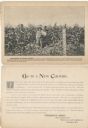
| Description: | A promotional card created to promote agricultural land in northern Wisconsin. This piece displays Julius Koehler, a man, and a woman in the flourishing ga... |

| Date: | 1870 |
|---|---|
| Description: | A map of Iowa County, Wisconsin mounted on cloth that shows the villages of Avoca, Mifflin, Linden, Arena, Helena Station, Highland, Dodgeville, as well as... |

| Date: | 1891 |
|---|---|
| Description: | Large group of people posed in, on and around the frame of a barn at a barn raising. A smaller building is in the background on the left. Cultivated fields... |

| Date: | 1840 |
|---|---|
| Description: | This map shows a line of proposed construction for defending the north side of the canal against inundation from the Wisconsin River and location of Fort W... |

| Date: | 1896 |
|---|---|
| Description: | This map shows railroads, churches, schools, cemeteries, rivers, lakes, and some rural property owners. |
If you didn't find the material you searched for, our Library Reference Staff can help.
Call our reference desk at 608-264-6535 or email us at: