 Filter: Categories of Wisconsin Historical Images
Filter: Subject of Land use, Rural
Filter: Subject of botany
Filter: Subject of land use, rural
Filter: Type of Map or Atlas
Filter: Categories of Wisconsin Historical Images
Filter: Subject of Land use, Rural
Filter: Subject of botany
Filter: Subject of land use, rural
Filter: Type of Map or Atlas

| Date: | 1935 |
|---|---|
| Description: | This map shows in different colors virgin timberland, second growth timber, pasture belt, crop-pasture belt, intensive crop-pasture belt, intensive pasture... |
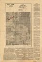
| Date: | 1935 |
|---|---|
| Description: | Map of a portion of Central Wisconsin with areas zoned for reforestation. The area is divided into two sites which are shaded in purple and red. |

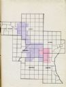
| Date: | 1935 |
|---|---|
| Description: | Map of Juneau County showing area zoned for reforestation shaded in red. |
| Date: | 1935 |
|---|---|
| Description: | This map shows land zoning. The top middle includes a key of land zones, forestry, recreation, and unrestricted. The map includes extensive text on zoning ... |

| Date: | 08 1960 |
|---|---|
| Description: | This map shows a detailed account of southwestern Wisconsin. Individual settlers, the type of trees that grow in given areas, the quality of the soil (labe... |

| Date: | 1973 |
|---|---|
| Description: | This map shows the uses of land in St. Croix County. Uses are indicated by colored dots. Residential(Yellow), Commercial(Red), Industrial(Grey), Parks and ... |

| Date: | 1970 |
|---|---|
| Description: | This map shows colored-coded land use with a legend in the bottom margin. Land classifications include: Year-round Residential (yellow), Seasonal Residenti... |

| Date: | 1973 |
|---|---|
| Description: | This map is 1 of 7 and includes a location map and township diagram in the margins. The map includes a key of land type: Residential (yellow), Commercial (... |

| Date: | 1973 |
|---|---|
| Description: | This map is 2 of 7 and includes a location map and township diagram in the bottom margin. The map includes a key of land type: Residential (yellow), Commer... |

| Date: | 1973 |
|---|---|
| Description: | This map is 3 of 7 and includes a location map and township diagram in the margins. The map includes a key of land type: Residential (yellow), Commercial (... |

| Date: | 1973 |
|---|---|
| Description: | This map is 4 of 7 and includes a location map and township diagram in the left margin. The map includes a key of land type: Residential (yellow), Commerci... |

| Date: | 1973 |
|---|---|
| Description: | This map is 5 of 7 and includes a location map and township diagram in the left margin. The map includes a key of land type: Residential (yellow), Commerci... |

| Date: | 1973 |
|---|---|
| Description: | This map is 6 of 7 and includes a location map and township diagram in the bottom margin. The map includes a key of land type: Residential (yellow), Commer... |

| Date: | 1973 |
|---|---|
| Description: | This map is 7 of 7 and includes a location map and township diagram in the left margin. The map includes a key of land type: Residential (yellow), Commerci... |

| Date: | 1776 |
|---|---|
| Description: | Map of New Jersey and New York, showing cities, forts, roads, counties, townships, land grants, rivers, lakes and several topographical features. Much of t... |

| Date: | 1776 |
|---|---|
| Description: | Map of Virginia and parts of Maryland and Delaware (written "De La War"). It shows borders, counties, cities, towns, plantations (marked by landowners name... |
If you didn't find the material you searched for, our Library Reference Staff can help.
Call our reference desk at 608-264-6535 or email us at: