 Filter: Categories of Wisconsin Historical Images
Filter: Subject of Land
Filter: Year of 1800-1899
Filter: Year of 1860-1869
Filter: Categories of Wisconsin Historical Images
Filter: Subject of Land
Filter: Year of 1800-1899
Filter: Year of 1860-1869
| Date: | 05 1864 |
|---|---|
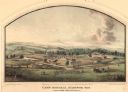
| Description: | Lithograph of Camp Randall, where the majority of Wisconsin's soldiers were trained and mustered into the Union Army. This view, which was taken from Basc... |

| Date: | 1862 |
|---|---|
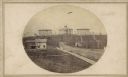
| Description: | Camp Randall looking southwest. In April 1861, Governor Alexander Randall asked that the State Agricultural Society fairgrounds be converted into a militar... |
| Date: | 1865 |
|---|---|
| Description: | University of Wisconsin-Madison campus showing the first three buildings on campus, South Hall (left), University Hall [Bascom Hall] (center), and North Ha... |
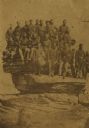
| Date: | 1864 |
|---|---|
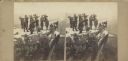
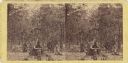
| Description: | Albumen stereograph of the Union Army brass band posed and playing atop Lookout Point. The Tennessee River is in the background. |
| Date: | 1869 |
|---|---|
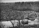
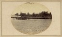
| Description: | Elevated view from steep shoreline of a log jam of about 150 million feet of logs, stopped at the piers of Pound, Halbert, and Co., which stood in about 40... |

| Date: | 1864 |
|---|---|
| Description: | This map shows pictorially a section of bracketdam, section of tree dam, and crib of stone. This map was prepared by order of General Joseph Bailey and is ... |
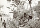
| Date: | 1863 |
|---|---|
| Description: | Stereograph of Gettysburg battlefield showing trees and a stump. Handwritten on reverse, "On the right of our line." This is probably a reference to the te... |
| Date: | 1866 |
|---|---|
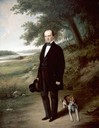
| Description: | Full-length portrait of Morgan L. Martin standing in a landscape, with a dog sitting at his feet. |
| Date: | 1864 |
|---|---|
| Description: | Elevated view of Battery C, 1st Regiment, Wisconsin Heavy Artillery at Fort Sherman, shown here after the battles of Missionary Ridge and Lookout Mountain.... |
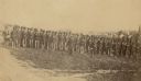
| Date: | 1861 |
|---|---|
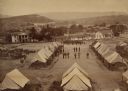
| Description: | Soldiers in formation at Camp Randall during winter. The season [there appears to be snow on the ground] and the tents indicate that this image was made in... |
| Date: | 04 20 1864 |
|---|---|
| Description: | Company D, Twenty-first Wisconsin Volunteer Infantry. Top row (left to right): John Buboltz, Spencer Orlup, J. Henry Otto, Lyman C. Wait, Andrew Jackson, W... |
| Date: | 1862 |
|---|---|
| Description: | Company I, 7th Regiment Wisconsin Volunteer Infantry, at Upton's Hill near Germantown, Virginia. The 7th was one of three Wisconsin regiments that was part... |
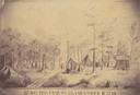
| Date: | 1862 |
|---|---|
| Description: | Sketch of the camp of the 15th Regiment of the Wisconsin Volunteer Infantry on Island No. 10 during the Civil War. Colonel Hans Christian Heg commanded the... |

| Date: | 1868 |
|---|---|
| Description: | The sidewheel packet, Keokuk, loaded with passengers beside a barge at a landing. The landing is filled with people and horse-drawn vehicles. The si... |

| Date: | 1861 |
|---|---|
| Description: | Drawn the first year of the Civil War, this colored 1861 map of Dane County shows its towns, cities and lakes. It includes insets of the wards of Madison a... |

| Date: | 1867 |
|---|---|
| Description: | Birds-eye drawing of Appleton, Outagamie Co., depicting street names and street layout, houses, the Fox River, the court house, jail, school houses, Lawren... |
| Date: | 1863 |
|---|---|
| Description: | Union army officers. From left are: General U.S. Grant, General Rawlins, General Webster, Colonel Lagow, and Colonel Killyer take a break. |

| Date: | 1869 |
|---|---|
| Description: | Birds-eye drawing of Boscobel, Grant County, depicts street names and street layouts, houses, rivers and trees. A reference key at the bottom of the map sh... |

| Date: | 1868 |
|---|---|
| Description: | This 1868 birds-eye view depicts the buildings, streets, railroad, vegetation and topography of Columbus, Wisconsin. The high school, cemetery, railroad de... |

| Date: | 1867 |
|---|---|
| Description: | Birds eye drawing of Fond du Lac depicts street names and street layouts, houses, buildings, trees, and the Fond du Lac River. A reference key at the botto... |
If you didn't find the material you searched for, our Library Reference Staff can help.
Call our reference desk at 608-264-6535 or email us at: