 Filter: Categories of Wisconsin Historical Images
Filter: Subject of Land
Filter: Subject of water-supply
Filter: Categories of Wisconsin Historical Images
Filter: Subject of Land
Filter: Subject of water-supply
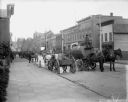
| Date: | 1900 |
|---|---|
| Description: | Horse-drawn wagons, including a water wagon, stand on a street next to a broad sidewalk in a commercial district. The storefronts of P.L. McQuillan and Con... |

| Date: | 1896 |
|---|---|
| Description: | A portion of John B. Heim's map of the Water Works System of Madison showing the size of the third Wisconsin Capitol (228' x 226') in comparison with the C... |

| Date: | |
|---|---|
| Description: | A view of school grounds at the Warm Springs Agency in Oregon shows the water supply and a bluff of over 1000 feet. |
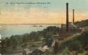
| Date: | 1910 |
|---|---|
| Description: | Elevated view from hill toward the building which has two large smokestacks. The Lake Michigan shoreline is on the left. In front is a landscaped area with... |

| Date: | 1896 |
|---|---|
| Description: | Shows pipes of various sizes, hydrants with hydrant pressure, valves, wells, projected lines, and suction pipes. Differs from earlier versions by inclusion... |

| Date: | 1894 |
|---|---|
| Description: | This map shows lot and block numbers, railroads, street car tracks, sewers, water mains, gas mains, paved streets, land owned by the Land & River Improveme... |
If you didn't find the material you searched for, our Library Reference Staff can help.
Call our reference desk at 608-264-6535 or email us at: