 Filter: Categories of Wisconsin Historical Images
Filter: Subject of Land
Filter: Subject of water
Filter: County of Dane
Filter: Categories of Wisconsin Historical Images
Filter: Subject of Land
Filter: Subject of water
Filter: County of Dane

| Date: | 1952 |
|---|---|
| Description: | Aerial view of a North Central Airlines DC-3 airplane flying over the Madison isthmus. Clearly visible are the Wisconsin State Capitol, the 1 West Wilson S... |

| Date: | 1940 |
|---|---|
| Description: | Aerial view looking east over the center of the city and the University of Wisconsin-Madison campus. |

| Date: | 1893 |
|---|---|
| Description: | Back of painting reads: "Madison in June 1837 after photo taken by E.E. Bailey" and "Peck's cabin by Dengel." The Eben Peck cabin was the first house built... |

| Date: | |
|---|---|
| Description: | The Eben Peck cabin was the first house built in Madison. |

| Date: | 1908 |
|---|---|
| Description: | Colored map showing a panoramic view of Madison in great detail. The Wisconsin State Capitol is located at the center, with Lake Mendota in the background ... |
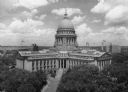
| Date: | 1945 |
|---|---|
| Description: | Elevated view of the Wisconsin State Capitol. The Belmont Hotel is behind the capitol on the left, and beyond is Lake Mendota. |

| Date: | 06 1837 |
|---|---|
| Description: | Lithograph based on a painting by Mrs. E.E. Bailey showing the Peck cabin, the first house in Madison. In addition to the cabin, the lithograph includes a ... |

| Date: | 1908 |
|---|---|
| Description: | A panoramic aerial view of the Isthmus taken from a kite. Lake Mendota is to the right in the background with Picnic Point jutting into the lake. The photo... |

| Date: | 1851 |
|---|---|
| Description: | Plat map of the Town of Madison (Township 7N, Range 9E), from Volume 4, Federal Survey Plat Books. |

| Date: | 1873 |
|---|---|
| Description: | Map of the township of Windsor, from the "Atlas of Dane County." |

| Date: | 1861 |
|---|---|
| Description: | Drawn the first year of the Civil War, this colored 1861 map of Dane County shows its towns, cities and lakes. It includes insets of the wards of Madison a... |
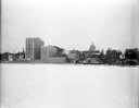
| Date: | 12 18 1955 |
|---|---|
| Description: | Downtown Madison lakeshore taken from Lake Monona in line with South Pinckney Street. Includes St. Raphael's steeple, 1 West Wilson Street state office bui... |

| Date: | 1876 |
|---|---|
| Description: | Bird's-eye view of Black Earth. |

| Date: | 05 09 1908 |
|---|---|
| Description: | Kite aerial panoramic photograph of the central business district. In the distance is Lake Mendota. The fire damaged Wisconsin State Capitol is in the cent... |

| Date: | 1839 |
|---|---|
| Description: | A map of the Wiskonsin [sic] and Neenah or Fox Rivers. |

| Date: | 1904 |
|---|---|
| Description: | Monona Bay from the railroad trestle looking southwest, close to where the railroad tracks cross North Shore Drive, (now Brittingham Park), with old houses... |

| Date: | 1897 |
|---|---|
| Description: | A view from the capitol looking west up State Street toward the University of Wisconsin-Madison with the Holy Redeemer Church, Holy Redeemer School, Red Gy... |

| Date: | 1879 |
|---|---|
| Description: | Bird's-eye view of Wisconsin State University, now the University of Wisconsin-Madison. Vignettes include Ladies Hall, South Dormitory, University Hall, As... |
If you didn't find the material you searched for, our Library Reference Staff can help.
Call our reference desk at 608-264-6535 or email us at:

