 Filter: Categories of Wisconsin Historical Images
Filter: Subject of Land
Filter: Subject of streetcars
Filter: Categories of Wisconsin Historical Images
Filter: Subject of Land
Filter: Subject of streetcars
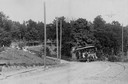
| Date: | 1886 |
|---|---|
| Description: | The first electric street railway in Wisconsin. |
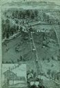
| Date: | |
|---|---|
| Description: | An engraving based on a drawing by Alexander Simplot. The image shows a very detailed aerial view of a hillside with a tramway traversing the side. There a... |

| Date: | 1916 |
|---|---|
| Description: | Southeastern Wisconsin which lies east of Whitewater and south of Port Washington. |

| Date: | 1910 |
|---|---|
| Description: | Elevated view of the Park Hotel, looking south from the Capitol Dome. Lake Monona is in the background. A streetcar is in the intersection. Caption reads: ... |

| Date: | 1870 |
|---|---|
| Description: | Slightly elevated view at an angle towards the left and front of the courthouse. A large statue is on top of the main dome. The area around the courthouse ... |

| Date: | 1927 |
|---|---|
| Description: | Street railway and motor bus map with a legend of "Street Car Line," "Auxiliary Bus Lines," and "Motor Bus Lines." The routes are numbered. The map reads: ... |

| Date: | 1938 |
|---|---|
| Description: | Color coded map in pink, yellow, blue, and brown of Milwaukee County State and County trunk highways. The map includes a legend of symbols: "STEAM RAIL ROA... |

| Date: | 1918 |
|---|---|
| Description: | This map shows railroads, street car lines, wards, private claims, parks, railroad yards and depots, and cemeteries. The map is oriented with north to uppe... |

| Date: | 1910 |
|---|---|
| Description: | This ink on paper blue line print base map consists of eight separate pieces and shows city limits, The Milwaukee Electric Railroad & Light Company lines, ... |

| Date: | 1927 |
|---|---|
| Description: | This map shows highways, roads, a proposed annexation, street car lines, bus routes, local motor bus lines, a new high speed interurban, railroads, a propo... |

| Date: | 1927 |
|---|---|
| Description: | View from street towards the corner of King Street and S. Pinckney Street. On the corner is the Haw-Olson Company. Down King Street is the Majestic Theater... |

| Date: | |
|---|---|
| Description: | View up center of King Street towards the third Wisconsin State Capitol. There are streetcar tracks, and large power poles are along the left side of the s... |

| Date: | 1925 |
|---|---|
| Description: | Elevated view of the southeast corner of Capitol Square. The Park Hotel is on the right and Lake Monona is in the background. An electric streetcar is goin... |

| Date: | |
|---|---|
| Description: | Elevated view of State Street from the Capitol. A streetcar is coming up the street, and automobiles are parked along the curbs. Lake Mendota is in the bac... |
If you didn't find the material you searched for, our Library Reference Staff can help.
Call our reference desk at 608-264-6535 or email us at: