 Filter: Categories of Wisconsin Historical Images
Filter: Subject of Land
Filter: Subject of shipping
Filter: Categories of Wisconsin Historical Images
Filter: Subject of Land
Filter: Subject of shipping

| Date: | 1890 |
|---|---|
| Description: | Bird's-eye map of Ashland, viewed from Lake Superior, with insets of Prentice Park and Fishery. Population 16,000. Increase in Ten Years, 11,000. |

| Date: | 1938 |
|---|---|
| Description: | A colorful pictorial map of Australia, featured on the front and back cover of a special Australian edition of International Trail. |
| Date: | 10 28 1938 |
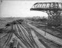
|---|---|
| Description: | Elevated view of railroad yard and railroads cars on Jones Island. On the right is a large derrick or crane, and in the background are a number of freighte... |

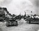
| Date: | 1945 |
|---|---|
| Description: | Marines use an International TD-9 crawler tractor (TracTracTor) and dozer shovel loader to unload supplies on a beach. A ship is in the background. The ori... |

| Date: | 1945 |
|---|---|
| Description: | Marines use an International TD-9 crawler tractor (TracTracTor) with a dozer shovel loader to fill a truck parked on a beach. A ship is in the water behind... |
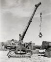
| Date: | 1945 |
|---|---|
| Description: | Seabees use an International crawler tractor (TracTracTor) with a crane ("cherry picker") to load cargo on a Western Pacific island. The text on the crane ... |
| Date: | 1945 |
|---|---|
| Description: | Marines use an International TD-18 Diesel crawler tractor (TracTracTor) to unload supplies and equipment from a ship. Many ships are in the water in the ba... |

| Date: | 1910 |
|---|---|
| Description: | View of a group of men and women sitting on the shore of Doller's Harbor. Nearby, a steamship can be seen at Doller's Wharf. Caption reads: "Doller's Wharf... |

| Date: | 1863 |
|---|---|
| Description: | A map of Illinois showing all railroads, stations, and towns. |
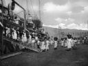
| Date: | |
|---|---|
| Description: | Women loading cargo onto a U.S. ship at St. Thomas in the Virgin Islands by way of baskets balanced on the tops of their heads. |
| Date: | |
|---|---|
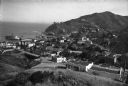
| Description: | Elevated view of a town located along a hilly shoreline. |

| Date: | |
|---|---|
| Description: | View of town toward Tongass Narrows where a ship sails on the water. |

| Date: | |
|---|---|
| Description: | Aerial view of town, showing the shoreline of Lake Superior, ore docks, roads, houses, buildings, trees, and smokestacks. Text describing this photograph s... |

| Date: | 1907 |
|---|---|
| Description: | A map of the eastern portion of the Apostle Islands group, and a detailed map of Gull Island showing the relief on the island, are included here, along wit... |

| Date: | 1872 |
|---|---|
| Description: | This 1872 map shows the proposed route of a canal between Sturgeon Bay, on the Green Bay side of the Door Peninsula, and Lake Michigan. Depths in both Stur... |

| Date: | 1887 |
|---|---|
| Description: | This map shows lot and block numbers, established dock lines, docks, slips, railroads, and streets of West Superior in 1887. |

| Date: | 1889 |
|---|---|
| Description: | This map shows lot and block numbers, established dock lines, docks, slips, railroads, and streets of West Superior in 1889. |

| Date: | 01 06 1958 |
|---|---|
| Description: | Ahnapee & Western Railway Bridge construction. View is from Highway Bridge. There are ships on the right side beyond the bridge. The forested shoreline cur... |

| Date: | 01 06 1958 |
|---|---|
| Description: | Ahnapee & Western Railway Bridge from north side of frozen Sturgeon Bay. The bridge is made of wood (and steel supports???). There is a dock in the foregro... |

| Date: | 1902 |
|---|---|
| Description: | This map is a chart of Milwaukee Harbor that displays local streets, bridges, roads, railroads, public buildings, businesses, factories, dry docks, parks, ... |
If you didn't find the material you searched for, our Library Reference Staff can help.
Call our reference desk at 608-264-6535 or email us at: