 Filter: Categories of Wisconsin Historical Images
Filter: Subject of Land
Filter: Subject of reservoirs
Filter: Categories of Wisconsin Historical Images
Filter: Subject of Land
Filter: Subject of reservoirs

| Date: | 02 06 1948 |
|---|---|
| Description: | Aerial view of west side, looking south along Glenway Street. Visible are the reservoir, Lake Wingra, Forest Hill and Resurrection Cemetery, Hoyt Park. Maj... |

| Date: | 02 06 1948 |
|---|---|
| Description: | Aerial photograph looking northwest across the reservoir on Glenway Street. Featured are Hoyt and Quarry Parks, Resurrection Cemetery. Major streets are Fr... |

| Date: | 02 06 1948 |
|---|---|
| Description: | Looking north along Glenway Street. Visible are the reservoir, Hoyt and Quarry Parks, Resurrection and Forest Hill Cemeteries, Rentschler Greenhouses, Fore... |

| Date: | 02 06 1948 |
|---|---|
| Description: | Looking southeast across Speedway Road. Visible are the reservoir on Glenway Street, Hoyt Park, Resurrection and Forest Hill cemeteries, Glenway Golf cours... |

| Date: | 02 06 1948 |
|---|---|
| Description: | Looking east along Regent Street with snow on the ground. Visible are Lake Wingra, Monona Bay, railroad causeway across Monona, Lake Mendota, Hoyt Park, We... |

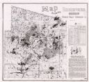
| Date: | 1930 |
|---|---|
| Description: | This map shows Indian trails through Wisconsin counties. The trail are in red ink. Lake Michigan, Green Bay, Lake Superior, and the Wisconsin River are lab... |
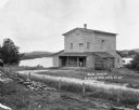
| Date: | 1924 |
|---|---|
| Description: | The Humbird Roller Mill surrounded by rural landscape. A man leads on a porch beam as he poses for the picture. |
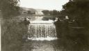
| Date: | 1935 |
|---|---|
| Description: | Five women pose at the dam built by Frank Lloyd Wright at his home near Spring Green, Wisconsin. A sixth figure is obscured by tree branches on the right. ... |

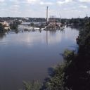
| Date: | |
|---|---|
| Description: | Elevated view from hill looking down at a river and reservoir. A railroad train is moving along railroad tracks on the opposite side of the river. Houses a... |

| Date: | 1941 |
|---|---|
| Description: | This is map one of three maps that show trails, roads and fire lanes, utilities, resorts, submerged lakes, vegetation, flowage right lands, and timber righ... |
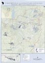
| Date: | 1987 |
|---|---|
| Description: | This map shows reservoirs, drainage areas, and parts of of Lincoln, Langlade, Forest, Oneida, and Vilas counties. Includes 1 inset map of corrections for R... |
| Date: | 2013 |
|---|---|
| Description: | This map shows hydroelectric dams, natural-lake and man-made reservoirs, the Wisconsin River and its tributaries, and the Wisconsin River Drainage Basin. T... |
| Date: | |
|---|---|
| Description: | Elevated view over trees towards the Fox River. A dam is creating a reservoir for hydroelectric power. Former paper mills are on the left shore of the rive... |
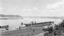
| Date: | 08 1940 |
|---|---|
| Description: | Elevated view of a coal barge pushed by a stern wheeled steamboat heading upstream from the Mississippi River Lock and Dam No. 9 north of Prairie du Chien,... |
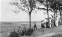
| Date: | 1936 |
|---|---|
| Description: | A crowd has gathered on a hilltop overlooking a large flat expanse which has been cleared of trees. A man is standing slightly downhill from the group and ... |
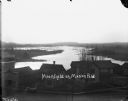
| Date: | 1900 |
|---|---|
| Description: | Elevated view over the tops of buildings to the water beyond. A wooden sidewalk and fence runs along the street in the foreground. Caption on negative read... |
If you didn't find the material you searched for, our Library Reference Staff can help.
Call our reference desk at 608-264-6535 or email us at: