 Filter: Categories of Wisconsin Historical Images
Filter: Subject of Land
Filter: Subject of niagara falls (n.y. and ont.)
Filter: Categories of Wisconsin Historical Images
Filter: Subject of Land
Filter: Subject of niagara falls (n.y. and ont.)

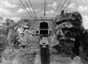
| Date: | 1916 |
|---|---|
| Description: | Slightly elevated view of people in the Whirlpool Aero Car, opened in 1916, departing from the station and crossing the whirlpool of Niagara Falls. |
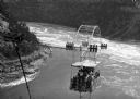
| Date: | 1916 |
|---|---|
| Description: | View looking up toward observers waiting for the Whirlpool Aero Car, built in 1913 and opened in 1916, to reach the station. |
| Date: | |
|---|---|
| Description: | Designed by Leonardo Torres y Quevedo and built in 1913. Elevated view looking down at people in the Whirlpool Aero Car which is crossing the 60-acre whirl... |

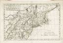
| Date: | 1733 |
|---|---|
| Description: | This map of North America shows settlements, rivers, lakes, Native American land, trade winds, and numerous topographical features such as forests and moun... |

| Date: | 11 24 1781 |
|---|---|
| Description: | Map showing New York, New England, and south eastern Canada. Boundaries, ports, and a few cities are shown, but the map focuses on regions, Native American... |

| Date: | 1777 |
|---|---|
| Description: | Map of Colonial America east of Lake Michigan showing regions, cities, forts, Native American land, mountains, lakes, and rivers. Crossed swords and small ... |

| Date: | 1720 |
|---|---|
| Description: | Detailed, ornate, and comprehensive map of America from the east coast to present day Texas. Numerous features appear throughout the map, including Native ... |
| Date: | 1783 |
|---|---|
| Description: | Map of the north east coast of the United States, north of Virginia and east of Lake Erie. It shows the states, forts, cities, towns, mountains, Niagara Fa... |

| Date: | 1760 |
|---|---|
| Description: | Map showing upstate New York, Lake Ontario, and the St. Lawrence River during the last, decisive battle of the French and Indian War. The main map shows a ... |

| Date: | 1795 |
|---|---|
| Description: | Detailed map of New York, showing counties, cities, mines, mills, roads, swamps, mountains, lakes and rivers. The map also shows Native American towns and ... |
If you didn't find the material you searched for, our Library Reference Staff can help.
Call our reference desk at 608-264-6535 or email us at: