 Filter: Categories of Wisconsin Historical Images
Filter: Subject of Land
Filter: Subject of michigan, lake
Filter: Categories of Wisconsin Historical Images
Filter: Subject of Land
Filter: Subject of michigan, lake

| Date: | 1856 |
|---|---|
| Description: | This map show the surveyed southern part of state and includes "profile of the Milwaukee and Mississippi Rail Road." Counties are shown in pink, green, blu... |
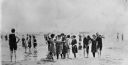
| Date: | 1910 |
|---|---|
| Description: | Popular bathing beaches like this one on Lake Michigan offered relief from the heat as well as the opportunity to be seen in the latest fashions of the 191... |

| Date: | 1848 |
|---|---|
| Description: | In 1849, northern Wisconsin was composed of huge sectional regions such as Chippewa, Portage, Brown and Crawford, whereas southern Wisconsin was constitute... |
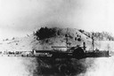
| Date: | |
|---|---|
| Description: | The sidewheel passenger and freight, "Milwaukee," at Dewey Hill, Grand Haven, Michigan, at the Detroit, Grand Haven and Milwaukee Railway depot. |
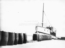
| Date: | |
|---|---|
| Description: | The screw ferry, "Wisconsin," docked at Washington Island. Twenty-one metal drums line the edge of the dock in the foreground. Original is in scrapbook on ... |

| Date: | |
|---|---|
| Description: | Map of the district of the Peshtigo fire, approximately 1,280,000 acres, in Wisconsin and Upper Michigan. |
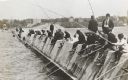
| Date: | 1910 |
|---|---|
| Description: | Long row of men in suits and hats fishing on the breakwater. |
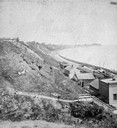
| Date: | 1877 |
|---|---|
| Description: | View of bluffs and buildings on the shore of Lake Michigan. |
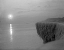
| Date: | 1912 |
|---|---|
| Description: | Sunrise over a frozen cliff on Lake Michigan. |

| Date: | 1886 |
|---|---|
| Description: | Cover of an advertising brochure for the Milwaukee Harvester Company featuring a color chromolithograph illustration of a farmer in a field operating a hor... |

| Date: | 1898 |
|---|---|
| Description: | Bird's-eye map, looking west from shoreline on Lake Michigan of Milwaukee to Golden Lake in Waukesha County, with Kenosha and Fox Point at bottom corners, ... |

| Date: | 1879 |
|---|---|
| Description: | Bird's-eye map of Two Rivers. |

| Date: | 1858 |
|---|---|
| Description: | Elevated view from bluff looking down on city, with Lake Michigan in background. Detailed foreground with two boys playing with a grounded kite, while a ma... |

| Date: | 1892 |
|---|---|
| Description: | Bird's-eye view of Chicago, with ships in the Lake Michigan harbor. |

| Date: | 1632 |
|---|---|
| Description: | The Wisconsin portion of Champlain's 1632 map, augmented since the previous one, for navigation according to the true Meridien, by Sieur de Champlain. The ... |

| Date: | 1892 |
|---|---|
| Description: | Bird's-eye view of the Columbian Exposition pavilions from the vantage point of Lake Michigan. Included is an inset of the Union Passenger Station (now Uni... |
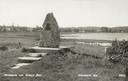
| Date: | 1940 |
|---|---|
| Description: | Memorial to the Moravians who arrived in Eagle Bay in 1853. |

| Date: | 1915 |
|---|---|
| Description: | View from hill across Eagle Bay with buildings and trees in the foreground. Caption reads: "Across Eagle Bay, Ephraim, Wis." |

| Date: | 1910 |
|---|---|
| Description: | View from hill towards downtown Fish Creek, with the buildings and ground covered in snow. There is a road in the foreground leading off to the left. The b... |
If you didn't find the material you searched for, our Library Reference Staff can help.
Call our reference desk at 608-264-6535 or email us at:
