 Filter: Categories of Wisconsin Historical Images
Filter: Subject of Land
Filter: Subject of loading docks
Filter: Categories of Wisconsin Historical Images
Filter: Subject of Land
Filter: Subject of loading docks
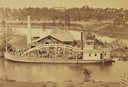
| Date: | 1872 |
|---|---|
| Description: | Elevated view from hill of the freight steamer "Cornucopia" loading hides at the Hammond Brothers warehouse, with Lawrence University buildings on the hill... |
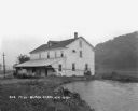
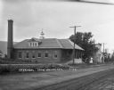
| Date: | 1910 |
|---|---|
| Description: | Exterior view of the Roller Mill with a covered loading dock. A sign on the end of the building at the roof line reads: "Roller Mill." Trees and power pole... |
| Date: | 1910 |
|---|---|
| Description: | View of the Van Camp Condensed Milk Factory. A driveway on the right leads up a small hill to the right side of the factory. Caption reads: "Van Camp Conde... |
| Date: | 1925 |
|---|---|
| Description: | View along shoreline of a mill on a river. There is a man loading bags onto a cart at the front. There is a wooded hill on the right. |
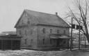
| Date: | 1922 |
|---|---|
| Description: | View from yard of blacksmith shop, a home, and a two-story building with a "Gold Medal Flour" sign. |
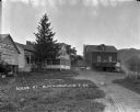
| Date: | 1925 |
|---|---|
| Description: | View down a winding dirt road with houses on both sides, as well as a large two-story building with a loading dock in front. Two people are in the back yar... |
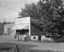
| Date: | 1918 |
|---|---|
| Description: | The exterior of P.J. Blindert's general store, with an awning over the storefront, and a loading dock on the left. A man and a woman stand in the road in f... |
| Date: | 1916 |
|---|---|
| Description: | View down driveway of two men and a woman stand on the open porch or loading dock of a building. A car is parked next to the group. There are other buildin... |
| Date: | 1922 |
|---|---|
| Description: | Exterior view across road of a creamery. The front of the creamery has a roof supported with columns over the elevated driveway and loading dock for delive... |
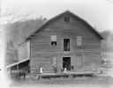
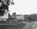
| Date: | |
|---|---|
| Description: | view of a woman, two girls, and a boy posed on the porch of a two-story wooden building, probably the John Edmunds' Charter Oak grist mill built on Squaw C... |

| Date: | |
|---|---|
| Description: | Aerial view of town, showing the shoreline of Lake Superior, ore docks, roads, houses, buildings, trees, and smokestacks. Text describing this photograph s... |
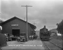
| Date: | 1928 |
|---|---|
| Description: | View down cobblestone platform of a group of young boys and men standing alongside the front of the depot. The locomotive on the tracks is Class A1 3012, a... |

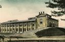
| Date: | 1926 |
|---|---|
| Description: | This 1926 map of Sawyer County, Wisconsin, the township and range system, towns, sections, cities and villages, railroads, highways and roads, and lakes an... |
| Date: | 1922 |
|---|---|
| Description: | Elevated view across water of a stone building next to an earthen dam on the La Crosse River. There is an archway on the side of the building at the river ... |
| Date: | 1908 |
|---|---|
| Description: | View of the Rundolph Mill and dam near Muscoda. A man stands near the far side of the bridge on the left. The banks of the river are rocky cliffs, and a st... |

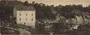
| Date: | |
|---|---|
| Description: | Elevated view of the Hillsboro Brewery when it was operated by Joseph Buzucha in the early 1900's. |

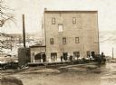
| Date: | |
|---|---|
| Description: | Exterior view of the Hillsboro Brewery when it was operated by Joseph Buzucha in the early 1900's. |
| Date: | |
|---|---|
| Description: | View from dirt road of a group of people (possibly employees) standing around the loading dock of the Hillsboro Mill. There is a steep, snow-covered hill i... |

| Date: | 1755 |
|---|---|
| Description: | Map of Virginia and parts of Maryland, North Carolina, and New Jersey. It shows borders, boundary lines, some Native American land, counties, cities, towns... |
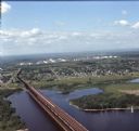
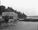
| Date: | 08 1971 |
|---|---|
| Description: | Aerial view of an ore dock next to Hog Island. The town is in the distance. In the far background are the white storage buildings of the oil refinery. |
If you didn't find the material you searched for, our Library Reference Staff can help.
Call our reference desk at 608-264-6535 or email us at: